
Town à Boston: Marches De L'armée in 1782
- Regular price
-
$115.95 - Regular price
-
$110.95 - Sale price
-
$115.95
Buy one map, get any other map in our collection for 50% OFF! Add to cart to see discount.
Couldn't load pickup availability
About This Map
Discover the timeless beauty of our fine art quality printed reproduction of this antique map. Perfect for history enthusiasts, collectors, and interior decorators.
Restored with meticulous attention to detail by our team with over a decade of experience, this stunning reproduction captures the intricate artistry and historical significance of the original map.
Whether you're a collector or seeking a unique decor piece, this archival-quality map reproduction is a timeless addition to any space. Order now to bring history to life!
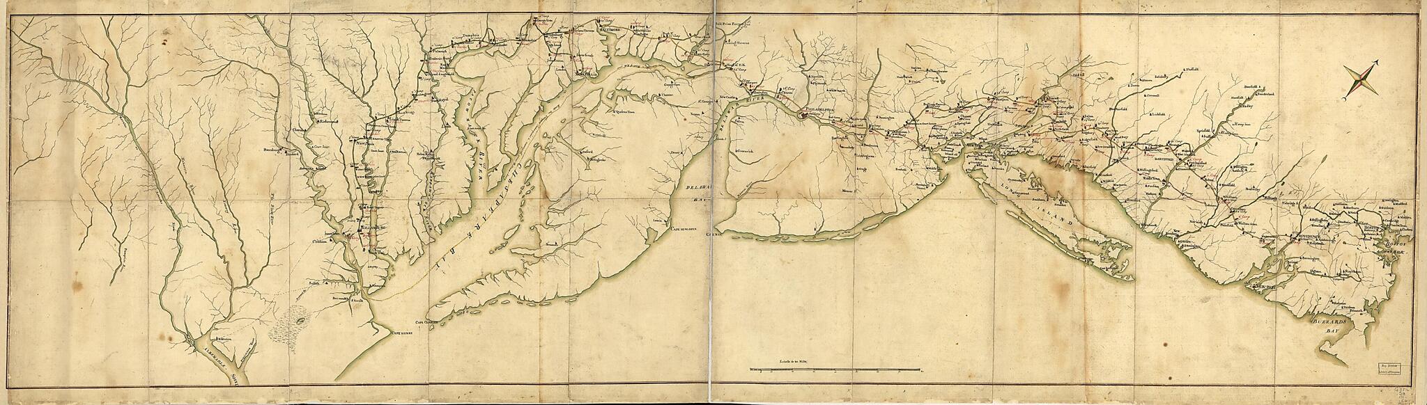
Old map of Middle Atlantic States, New England, United States.- Scale ca. 1:650,000.
- Title from manuscript label on verso as originally mounted.
- Manuscript, pen-and-ink and watercolor.
- Oriented with north toward the upper right.
- Key map of the route of march of Comte de Rochambeau's army from Providence, R.I., to Yorktown, Va., and the return march to Boston.
- The yellow line from Providence to Head of Elk and Annapolis, Md., and down Chesapeake Bay to Williamsburg and Yorktown (camps 1-40) shows the march south from June 10 to September 30, 1781. The green line from "Scott's House" southward to Williamsburg shows the route of the supply train, and the read line from Lebanon, Conn., to Philipsburg, N.Y., represnts the flanking march of Lauzun's Legion.
- Camps on the return march follow the green line from Williamsburg to "Spurrier's Tavern" and continue along the yellow line to Boston. Camps along the red line from Princeton, N.J., to King's Ferry represent the flanking march of Lauzun's Legion on the return march.
- Title from manuscript label on verso as originally mounted.
- The complete title as it appears on another version of the map reads: "Carte générale des camps et marches et des troupes françaises sous les ordres du Lieutenant General Comte de Rochambeau, de Rhode Island à York en Verginie, et des camps occupés au retour de l'armée française de York à Boston: du 9 Juin 1781, au ler. Décembre 1782."
- Shows military camps.
- For information on other version of the map see Rice and Brown, American Campaigns of Rochambeau's Army, 1972, v. 2, p. 196-97.
Map Subjects
Early Works To 1800
History
Maps Manuscript
Middle Atlantic States
New England
Revolution
United States
1782
- For the best legibility, order your map in the original size or larger. Most maps have intricate detail and small text that is best appreciated when the print size hasn't been reduced.
- Sizes labeled "Fits a Standard Frame" will drop right into any frame that you purchase in that size. The sizes that we offer are commonly available online and at most retail stores.
- Our standard sizes are recommendations based on the aspect ratio of the original map, but still may require some added "white space" in one dimension to fit.
- Non-standard sizes will require custom framing, and we suggest taking your print to the frame shop of your choice after you receive it for the best results.
- Custom sizes are available, simply contact us for a quote.
Below is an approximation of the scale of a few standard sizes, and how they might appear in your space.
