
Travel Routes of Northern Arabia 1884
- Regular price
-
$61.95 - Regular price
-
$43.95 - Sale price
-
$61.95
Buy one map, get any other map in our collection for 50% OFF! Add to cart to see discount.
Couldn't load pickup availability
About This Map
Discover the timeless beauty of our fine art quality printed reproduction of this antique map. Perfect for history enthusiasts, collectors, and interior decorators.
Restored with meticulous attention to detail by our team with over a decade of experience, this stunning reproduction captures the intricate artistry and historical significance of the original map.
Whether you're a collector or seeking a unique decor piece, this archival-quality map reproduction is a timeless addition to any space. Order now to bring history to life!
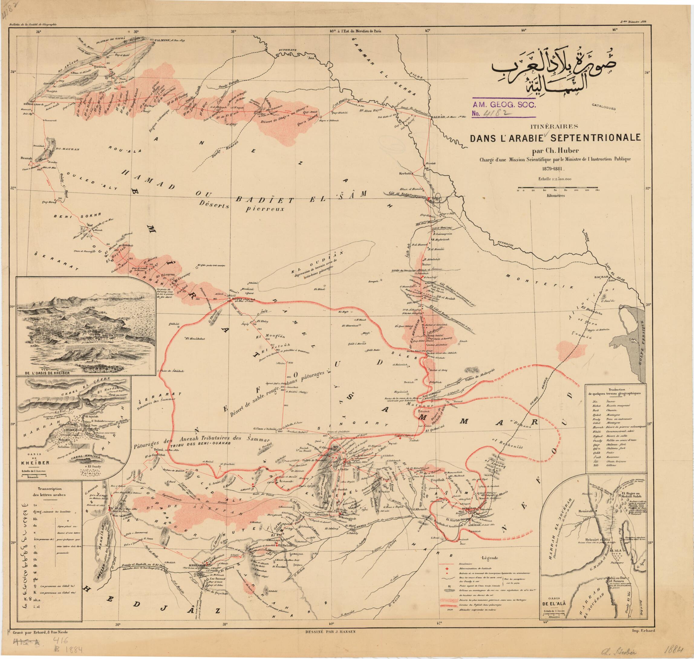
Old map of Iraq, Saudi Arabia.day Saudi Arabia) in the south. The map was published by the Société de Géographie (Geographical Society) of France in 1884. It provides little precise topographic detail, but significant features such as "basalt plateau" or "year-round water flow" are noted. Approximate boundaries of some tribal subdivisions of the widely dispersed Shammar confederation are shown with indication of their traditional pasturage. Also marked are oases and pre-Islamic sites. Inset maps give details of the oasis towns of Khaybar and Madaʼin Salih. Relief is shown by contour lines and spot elevation in meters, and scale is given in kilometers. An Arabic-French glossary of topographical terms and a key to transliteration of Arabic words are provided. French traveler Charles Huber (1837-84) explored this area in 1879-81 under a charge from the French minister of education, and again in 1883-84. This map was made during his first exploration. More detailed maps and sketches accompanied the publication of his full travel account, Journal d'un voyage en Arabie, 1883-1884 (Journal of an expedition in Arabia, 1883-1884). Huber's travels and publications were sponsored by the French government and by the Société. In 1884, while on his second trip, Huber was robbed near Jiddah and murdered by his guides. The map appeared in the Bulletin of the Société. It was designed by cartographer Jules Hanson (1849-1931) and produced at the Erhard Press, a prominent engraver and printer.
Created by Geographical Society (France), Jules Hansen, Charles Huber in 1884.
- Title devised, in English, by Library staff.
- "Scale 1:2,500,000"--Note extracted from World Digital Library.
- Original resource extent: 1 map : color ; 45 x 49 centimeters.
- Original resource at: University of Wisconsin-Milwaukee Libraries.
- Content in Arabic and French.
- Description based on data extracted from World Digital Library, which may be extracted from partner institutions.
- For the best legibility, order your map in the original size or larger. Most maps have intricate detail and small text that is best appreciated when the print size hasn't been reduced.
- Sizes labeled "Fits a Standard Frame" will drop right into any frame that you purchase in that size. The sizes that we offer are commonly available online and at most retail stores.
- Our standard sizes are recommendations based on the aspect ratio of the original map, but still may require some added "white space" in one dimension to fit.
- Non-standard sizes will require custom framing, and we suggest taking your print to the frame shop of your choice after you receive it for the best results.
- Custom sizes are available, simply contact us for a quote.
Below is an approximation of the scale of a few standard sizes, and how they might appear in your space.

