
Traveled Routes : Showing Principal Roads In the Northern and Central Western States, and Their Connections With the Main-traveled Highways of the South : Eastern U.S. (Routes Between the Northern States, Middle Western States, and the South) 1911
- Regular price
-
$82.95 - Regular price
-
$77.95 - Sale price
-
$82.95
Buy one map, get any other map in our collection for 50% OFF! Add to cart to see discount.
Couldn't load pickup availability
About This Map
Discover the timeless beauty of our fine art quality printed reproduction of this antique map. Perfect for history enthusiasts, collectors, and interior decorators.
Restored with meticulous attention to detail by our team with over a decade of experience, this stunning reproduction captures the intricate artistry and historical significance of the original map.
Whether you're a collector or seeking a unique decor piece, this archival-quality map reproduction is a timeless addition to any space. Order now to bring history to life!
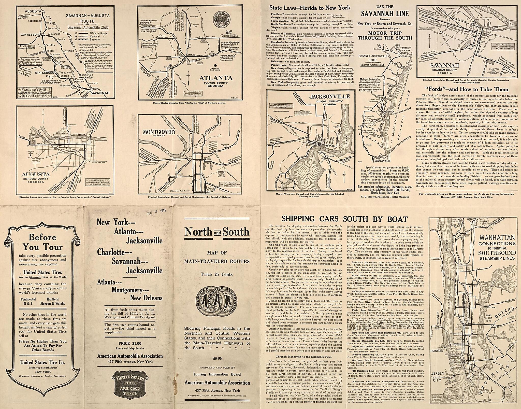
Old road map of East, United States.Created by American Automobile Association. Route & Map Service, American Automobile Association. Touring Information Board in 1911.
- Road map of Eastern U.S.
- Also shows car-carrying steamship routes between New York City, Galveston, and intermediate ports.
- Title from panel.
- Includes notes and New York metro-area inset.
- Text, 5 city route maps, map of Manhattan steamship line piers, 2 Savannah approach route maps, AAA logotype, and advertisements on verso.
- In lower right corner: D.M.
Map Subjects
East
East (U.S.)
Road Maps
Roads
Steamboat Lines
United States
American Automobile Association. Route & Map Service
American Automobile Association. Touring Information Board
1911
- For the best legibility, order your map in the original size or larger. Most maps have intricate detail and small text that is best appreciated when the print size hasn't been reduced.
- Sizes labeled "Fits a Standard Frame" will drop right into any frame that you purchase in that size. The sizes that we offer are commonly available online and at most retail stores.
- Our standard sizes are recommendations based on the aspect ratio of the original map, but still may require some added "white space" in one dimension to fit.
- Non-standard sizes will require custom framing, and we suggest taking your print to the frame shop of your choice after you receive it for the best results.
- Custom sizes are available, simply contact us for a quote.
Below is an approximation of the scale of a few standard sizes, and how they might appear in your space.

