
Tung, Zu Beiden Seiten Des Meridians Von Macao 1834
- Regular price
-
$69.95 - Regular price
-
$64.95 - Sale price
-
$69.95
Buy one map, get any other map in our collection for 50% OFF! Add to cart to see discount.
Couldn't load pickup availability
About This Map
Discover the timeless beauty of our fine art quality printed reproduction of this antique map. Perfect for history enthusiasts, collectors, and interior decorators.
Restored with meticulous attention to detail by our team with over a decade of experience, this stunning reproduction captures the intricate artistry and historical significance of the original map.
Whether you're a collector or seeking a unique decor piece, this archival-quality map reproduction is a timeless addition to any space. Order now to bring history to life!
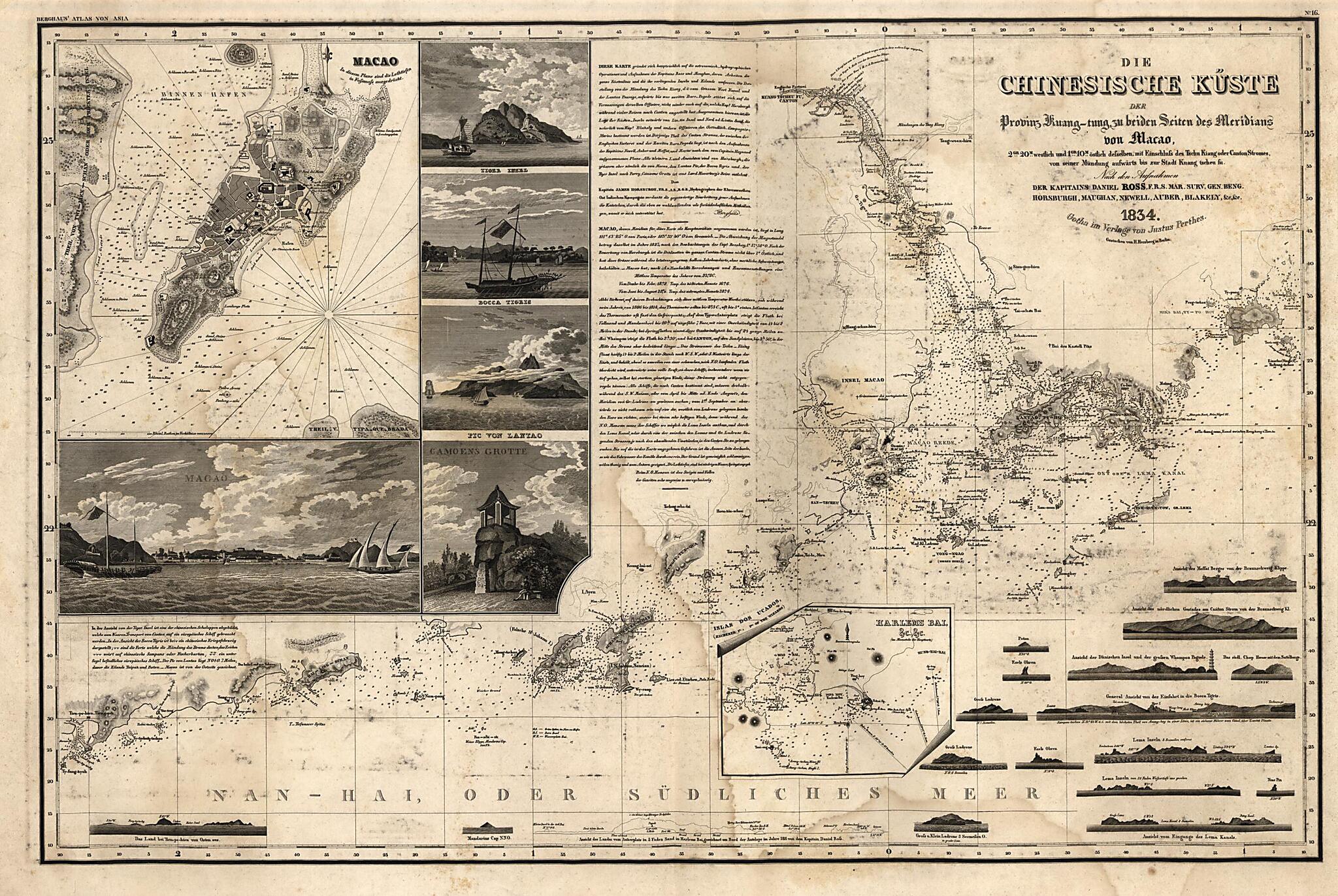
Old nautical chart of China, Macau, Macau (Special Administrative Region), Pearl River Estuary, Special Administrative Region.scale early 19th century chart of the mouth of the Pearl River focusing on the region around present-day Macao and Hong Kong. The top left of the engraving is filled with a detailed plan of Macao surrounded by smaller engravings of Tiger Island, the Bocca Tigris, Lantao and a profile of Macao, and the famous view of Luis de Camoens' Grotto at Macao with detailed annotations and description below. A detailed inset lower center shown Harlem & Bias Bays to the North of Mirs Bay. Hong Kong is well detailed and named with Ty-tam Bai also indentified. Lantau and Lamma are also well detailed. The lower and right hand areas are filled with well-detailed profile views of the Islands, coastlines, and shores of the Pearl River area.
Created by Heinrich Karl Wilhelm Berghaus in 1834.
- Relief show by hachures. Depths shown by soundings.
- "Berghaus' Atlas von Asia, no. 16"
- Includes a lengthy annotations on the chart's sources and on the topography of Macao, Canton and the Pearl River area.
- [Nautical chart of the Pearl River Estuary] -- Macao.
Map Subjects
China
Macau (China : Special Administrative Region)
Macau (Special Administrative Region)
Nautical Charts
Pearl River Estuary
Pearl River Estuary (China)
Macau
Special Administrative Region
Heinrich Karl Wilhelm Berghaus
1834
- For the best legibility, order your map in the original size or larger. Most maps have intricate detail and small text that is best appreciated when the print size hasn't been reduced.
- Sizes labeled "Fits a Standard Frame" will drop right into any frame that you purchase in that size. The sizes that we offer are commonly available online and at most retail stores.
- Our standard sizes are recommendations based on the aspect ratio of the original map, but still may require some added "white space" in one dimension to fit.
- Non-standard sizes will require custom framing, and we suggest taking your print to the frame shop of your choice after you receive it for the best results.
- Custom sizes are available, simply contact us for a quote.
Below is an approximation of the scale of a few standard sizes, and how they might appear in your space.
