
Turquie D'Europe Pour Servir Au Théâtre De La Guerre Des Turcs Et Des Russes in 1855
- Regular price
-
$49.95 - Regular price
-
$34.95 - Sale price
-
$49.95
Buy one map, get any other map in our collection for 50% OFF! Add to cart to see discount.
Couldn't load pickup availability
About This Map
Discover the timeless beauty of our fine art quality printed reproduction of this antique map. Perfect for history enthusiasts, collectors, and interior decorators.
Restored with meticulous attention to detail by our team with over a decade of experience, this stunning reproduction captures the intricate artistry and historical significance of the original map.
Whether you're a collector or seeking a unique decor piece, this archival-quality map reproduction is a timeless addition to any space. Order now to bring history to life!
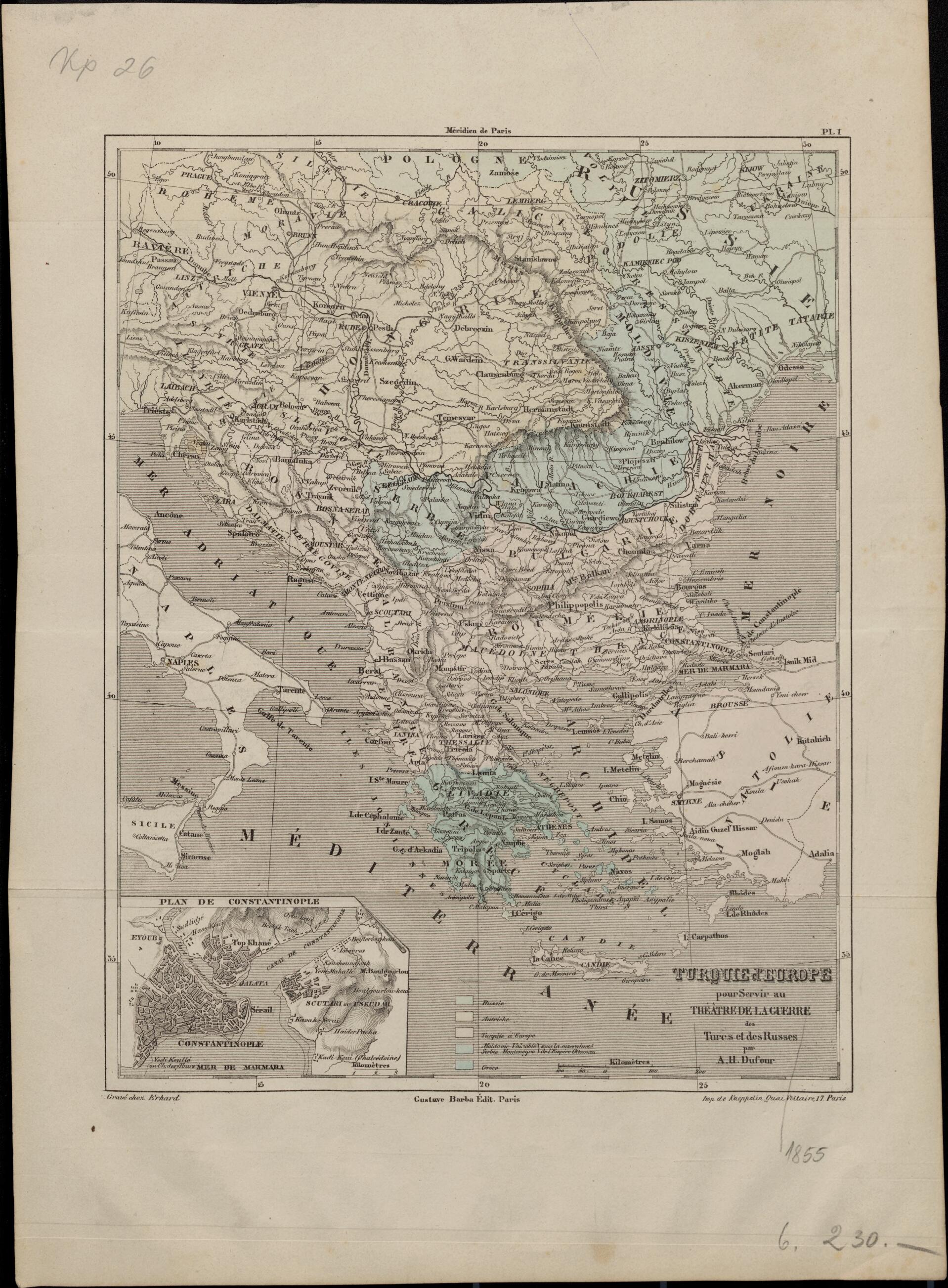
Old map of Albania, Bosnia and Herzegovina, Bulgaria, Former Yugoslav Republic of Macedonia, Greece, Istanbul, Italy, Moldova, Montenegro, Romania, Serbia, Turkey.56) that pitted Russia against the Ottoman Empire (Turkey) and its allies Britain, France, and Sardinia. The western European powers backed the Turks in order to block Russia's expansion into the Black Sea region, which they believed threatened their positions in the Middle East and the Mediterranean. Many of the war's major battles were fought on the Crimean Peninsula in southern Russia, which, ironically, is not shown on this early map of the "theater of war." The conflict ended with the Treaty of Paris, signed on March 30, 1856, in which Russia was forced to give up territory it had seized from the Ottomans. Color codes are used to indicate the Russian, Austrian, and Turkish Empires, as well as Greece, which had secured its independence from the Ottoman Empire in 1832, Moldavia, and the principalities of Wallachia (present-day Romania), Serbia, and Montenegro. The latter were territories nominally under Ottoman suzerainty, but which were autonomous and under Russian influence. The inset map at the lower left shows Constantinople (Istanbul), the Ottoman capital. A single distance scale is given, in kilometers, reflecting the standardization that came with increasing use of the metric system in the mid-19th century.
Created by A.H. (Auguste Henri) Dufour in 1855.
- Title devised, in English, by Library staff.
- "Scale 1:4,400,000"--Note extracted from World Digital Library.
- Original resource extent: 1 map ; 30 x 41 centimeters.
- Original resource at: National and University Library "St Kliment Ohridski" -- Skopje.
- Content in French.
- Description based on data extracted from World Digital Library, which may be extracted from partner institutions.
- For the best legibility, order your map in the original size or larger. Most maps have intricate detail and small text that is best appreciated when the print size hasn't been reduced.
- Sizes labeled "Fits a Standard Frame" will drop right into any frame that you purchase in that size. The sizes that we offer are commonly available online and at most retail stores.
- Our standard sizes are recommendations based on the aspect ratio of the original map, but still may require some added "white space" in one dimension to fit.
- Non-standard sizes will require custom framing, and we suggest taking your print to the frame shop of your choice after you receive it for the best results.
- Custom sizes are available, simply contact us for a quote.
Below is an approximation of the scale of a few standard sizes, and how they might appear in your space.

