
Turkey In Europe: According to New Observations by the Gentlemen at the Royal Science Academy. (Turquie En Europe : Suivant Les Nouvelles Observations De Messrs De L'Academie Royale Des Sciences) 1729
- Regular price
-
$49.95 - Regular price
-
$34.95 - Sale price
-
$49.95
Buy one map, get any other map in our collection for 50% OFF! Add to cart to see discount.
Couldn't load pickup availability
About This Map
Discover the timeless beauty of our fine art quality printed reproduction of this antique map. Perfect for history enthusiasts, collectors, and interior decorators.
Restored with meticulous attention to detail by our team with over a decade of experience, this stunning reproduction captures the intricate artistry and historical significance of the original map.
Whether you're a collector or seeking a unique decor piece, this archival-quality map reproduction is a timeless addition to any space. Order now to bring history to life!
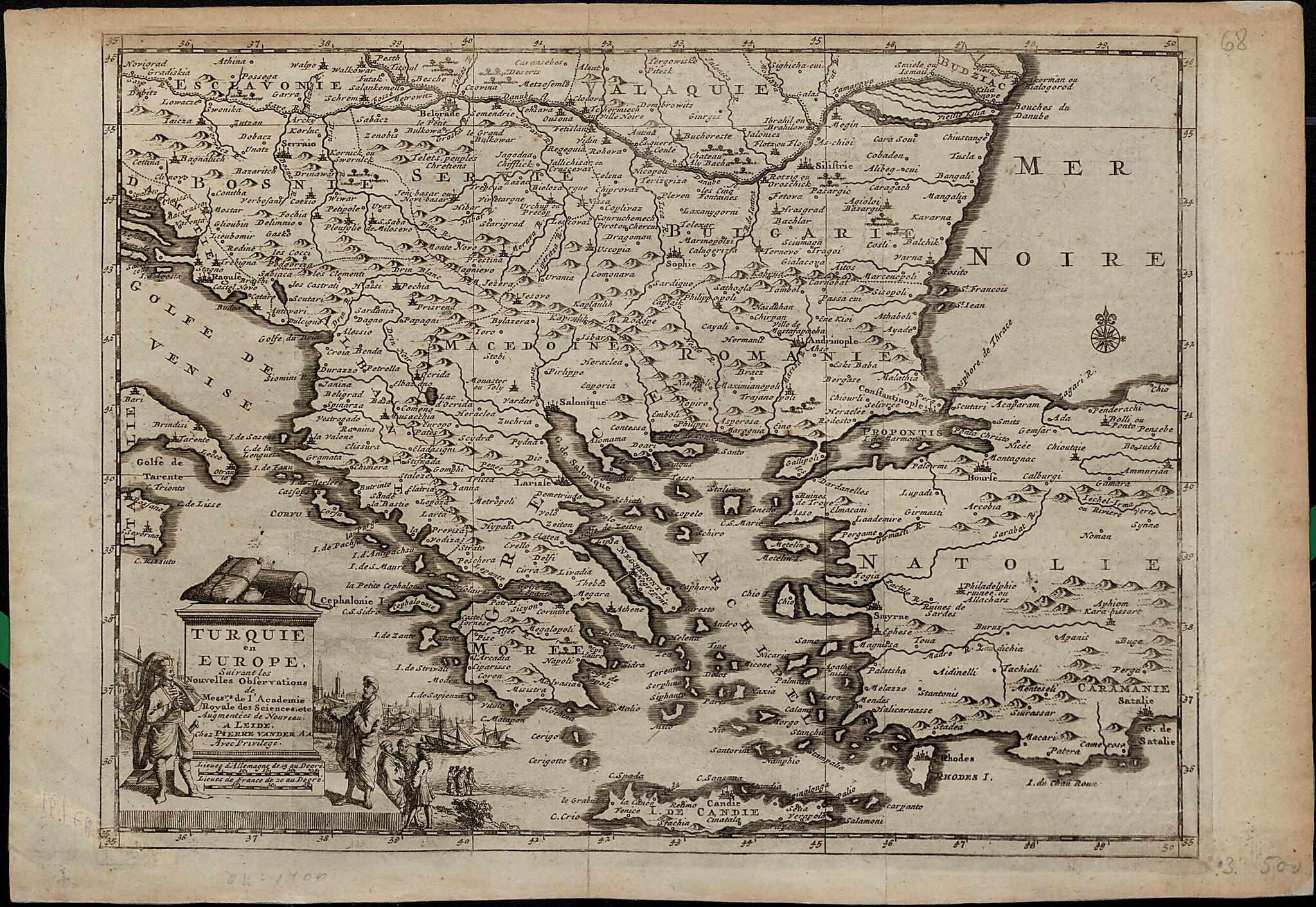
Old map of Albania, Bosnia and Herzegovina, Bulgaria, Croatia, Former Yugoslav Republic of Macedonia, Greece, Montenegro, Serbia, Turkey.1733) was a Dutch publisher and bookseller, based in Leiden, who specialized in reissuing maps acquired from earlier mapmakers. Van der Aa's major work was the elaborate Galerie Agréable du Monde (The pleasurable gallery of the world), a compendium of some 3,000 maps in 66 parts, bound in 27 volumes, and completed in 1729. Presented here is van der Aa's map of the European provinces of the Ottoman Empire, which in the early 18th century included present-day Albania, Bosnia and Herzegovina, Bulgaria, the Former Yugoslav Republic of Macedonia (FYROM), Greece, Romania, Serbia, and the European part of Turkey. Two distance scales are provided: French leagues and German leagues. The illustration surrounding the cartouche in the lower left-hand corner shows an Ottoman soldier and an Ottoman official, and what appears to be a view of two Turkish merchants conversing with a European associate. In the background is the harbor and city of Constantinople, identifiable by its hills and minarets.
Created by Pieter Van Der Aa in 1729.
- Title devised, in English, by Library staff.
- "Scale 1:4,400,000"--Note extracted from World Digital Library.
- Original resource extent: 1 map ; 35 x 24.5 centimeters.
- Reference extracted from World Digital Library: Bagrow, Leo. History of Cartography (revised and enlarged by R.A. Skelton) (Cambridge: Harvard University Press, 1964).
- Original resource at: National and University Library "St Kliment Ohridski" -- Skopje.
- Content in French.
- Description based on data extracted from World Digital Library, which may be extracted from partner institutions.
Map Subjects
Albania
Balkan Peninsula
Bosnia And Herzegovina
Bulgaria
Croatia
Former Yugoslav Republic Of Macedonia
Greece
Montenegro
Ottoman Empire
Serbia
Turkey
Pieter Van Der Aa
1729
- For the best legibility, order your map in the original size or larger. Most maps have intricate detail and small text that is best appreciated when the print size hasn't been reduced.
- Sizes labeled "Fits a Standard Frame" will drop right into any frame that you purchase in that size. The sizes that we offer are commonly available online and at most retail stores.
- Our standard sizes are recommendations based on the aspect ratio of the original map, but still may require some added "white space" in one dimension to fit.
- Non-standard sizes will require custom framing, and we suggest taking your print to the frame shop of your choice after you receive it for the best results.
- Custom sizes are available, simply contact us for a quote.
Below is an approximation of the scale of a few standard sizes, and how they might appear in your space.
