
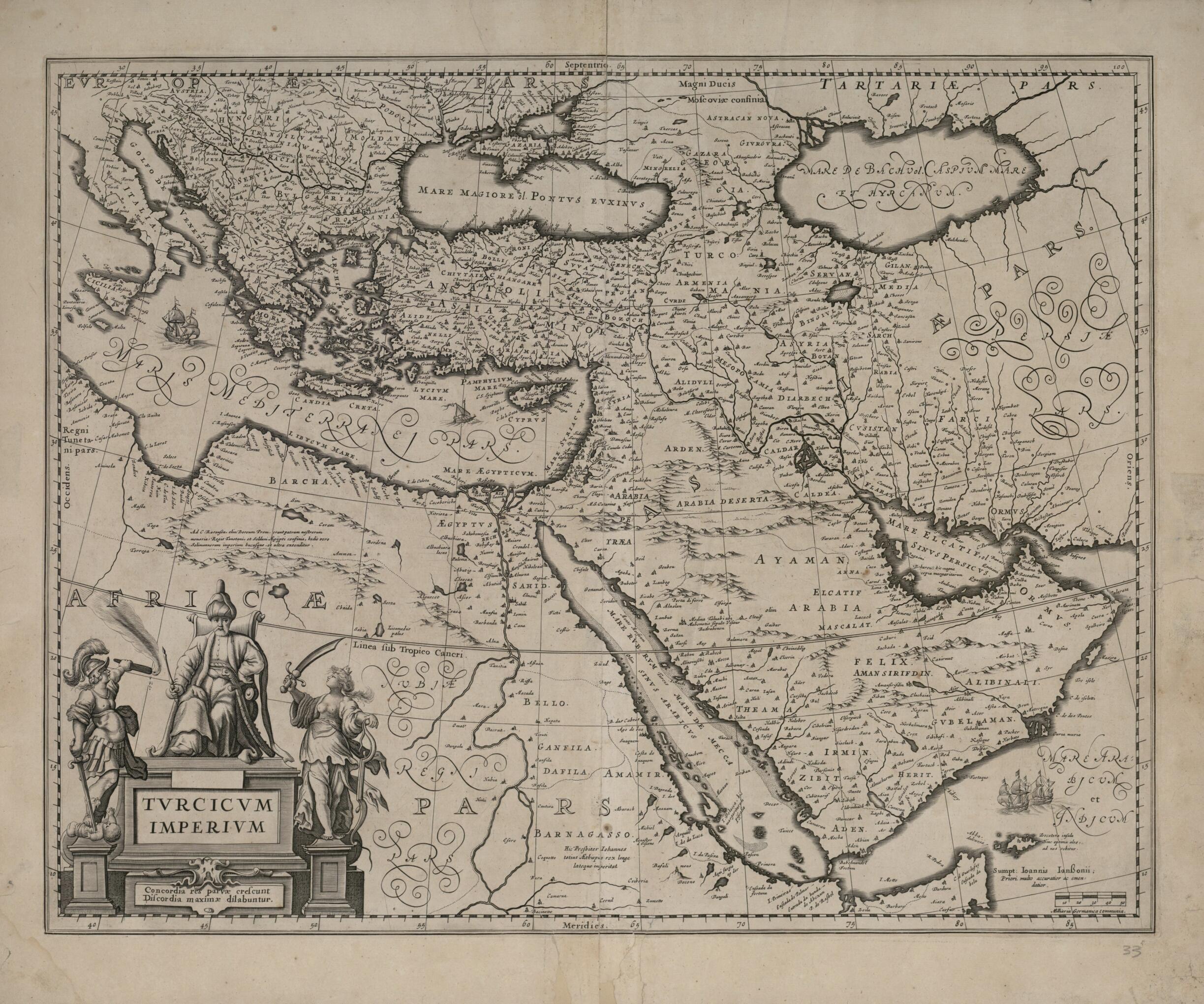
Turkish Empire. (Tvrcicvm Imperivm) 1635
- Regular price
-
$84.95 - Regular price
-
$79.95 - Sale price
-
$84.95
Buy one map, get any other map in our collection for 50% OFF! Add to cart to see discount.
Couldn't load pickup availability
About This Map
Discover the timeless beauty of our fine art quality printed reproduction of this antique map. Perfect for history enthusiasts, collectors, and interior decorators.
Restored with meticulous attention to detail by our team with over a decade of experience, this stunning reproduction captures the intricate artistry and historical significance of the original map.
Whether you're a collector or seeking a unique decor piece, this archival-quality map reproduction is a timeless addition to any space. Order now to bring history to life!
Old map of Albania, Armenia, Azerbaijan, Bosnia and Herzegovina, Bulgaria, Croatia, Cyprus, Egypt, Former Yugoslav Republic of Macedonia, Georgia, Greece, Hungary, Iran, Islamic Republic of, Iraq, Israel, Italy, Jordan, Kuwait, Lebanon, Moldova, Oman, Qatar, Romania, Saudi Arabia, Serbia, Slovenia, Syrian Arab Republic, Turkey, United Arab Emirates, Yemen.1638) in about 1635, when the Ottoman territories included the Balkans, Anatolia, the Levant, and parts of Hungary, Ukraine, North Africa and Arabia. The map centers on the eastern Mediterranean (marked Mare Syriacum, or Syrian Sea) and northern Arabia, and it extends from Italy in the west to the Black Sea and Caspian Sea in the north, the Persian Gulf in the east, and the Arabian Sea and Gulf of Aden in the south. A student of celebrated Danish astronomer Tycho Brahe, Blaeu was first known as an astronomer and maker of globes and other instruments before he became famed as a cartographer and publisher. He began producing maps and charts in the first years of the 17th century. A considerable rivalry developed between Blaeu and fellow Amsterdam cartographers and partners Johannes Janssonius and Jodocus Hondius, the younger. When Hondius died in 1629, his widow nevertheless sold the Mercator-Hondius copperplates to Blaeu rather than passing them to the firm of Hondius and Janssonius. Blaeu adapted and used these plates in his first atlas, the Atlantis Appendix, published in 1630, and in his Theatrum Orbis Terrarum sive Atlas Novus (New map and atlas of the world), published in 1635, of which this map formed part. A decorative title cartouche shows a seated sultan with two supporters flourishing weapons. Two sailing ships appear in the Arabian Sea above a scale in German common miles. Text in Spanish on the verso is on the early history of the Turkish Empire. Willem Janzoon died before the completion of his next great project, realized by his son Joan Blaeu (1596-1673). This was the Atlas Major (or Maior), the largest and most splendid of 17th-century world atlases, published in 1662, in 11 volumes with almost 600 double-page maps and more than 3,000 pages of text.
Created by Joan Blaeu, Willem Janszoon Blaeu in 1635.
- Title devised, in English, by Library staff.
- "Scale approximately 1:11,000,000"--Note extracted from World Digital Library.
- Original resource extent: 1 map : black-and-white ; 39 x 49.8 centimeters.
- Original resource at: Qatar National Library.
- Content in Latin.
- Description based on data extracted from World Digital Library, which may be extracted from partner institutions.
- For the best legibility, order your map in the original size or larger. Most maps have intricate detail and small text that is best appreciated when the print size hasn't been reduced.
- Sizes labeled "Fits a Standard Frame" will drop right into any frame that you purchase in that size. The sizes that we offer are commonly available online and at most retail stores.
- Our standard sizes are recommendations based on the aspect ratio of the original map, but still may require some added "white space" in one dimension to fit.
- Non-standard sizes will require custom framing, and we suggest taking your print to the frame shop of your choice after you receive it for the best results.
- Custom sizes are available, simply contact us for a quote.
Below is an approximation of the scale of a few standard sizes, and how they might appear in your space.

