
Unis De L'Amérique Suivant Le Traité De Paix De espace Vide 1805
- Regular price
-
$94.95 - Regular price
-
$89.95 - Sale price
-
$94.95
Buy one map, get any other map in our collection for 50% OFF! Add to cart to see discount.
Couldn't load pickup availability
About This Map
Discover the timeless beauty of our fine art quality printed reproduction of this antique map. Perfect for history enthusiasts, collectors, and interior decorators.
Restored with meticulous attention to detail by our team with over a decade of experience, this stunning reproduction captures the intricate artistry and historical significance of the original map.
Whether you're a collector or seeking a unique decor piece, this archival-quality map reproduction is a timeless addition to any space. Order now to bring history to life!
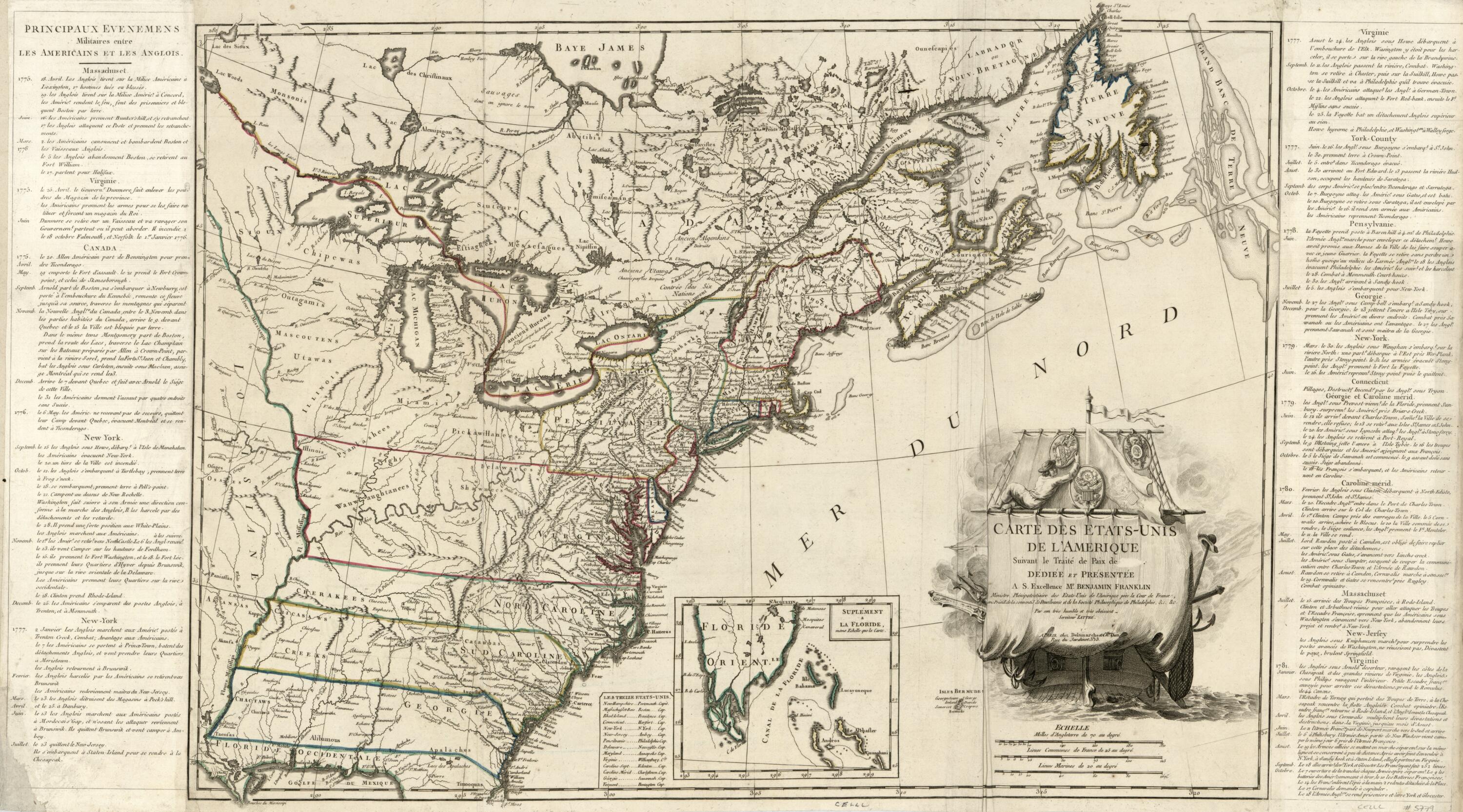
Old map of Canada, United States.Created by Charles François Delamarche, Charles Dien, Jean Lattré in 1805.
- Covers the area east of the Mississippi River from James Bay to Gulf of Mexico to Newfoundland.
- Relief shown pictorially.
- Shows location of Washington D.C. and includes Vermont in the list of "Les treize Etats-Unis".
- Prime meridian: Ferro.
- Watermark: BAR.
- This map has some imperfections: trimmed at upper left, has paper strip affixed to left edge as if removed from bound vol., fold-lined, darkened at right edge. We'll do our best to restore the image before printing.
- Purchase; Richard Arkway; 2002.
- Includes text of "Principaux evenemens [sic] militaires entre les Americains et les Anglois", inset "Suplément a La Floride", list of names of the 13 states, and pictorial title cartouche with coats-of-arms.
- Acquisitions control no.: 2002-24
- For the best legibility, order your map in the original size or larger. Most maps have intricate detail and small text that is best appreciated when the print size hasn't been reduced.
- Sizes labeled "Fits a Standard Frame" will drop right into any frame that you purchase in that size. The sizes that we offer are commonly available online and at most retail stores.
- Our standard sizes are recommendations based on the aspect ratio of the original map, but still may require some added "white space" in one dimension to fit.
- Non-standard sizes will require custom framing, and we suggest taking your print to the frame shop of your choice after you receive it for the best results.
- Custom sizes are available, simply contact us for a quote.
Below is an approximation of the scale of a few standard sizes, and how they might appear in your space.
