
Valentia Edetanorum, Plebs of Cid. (Valentia Edetanorum, Vulgo Del Cid) 1705
- Regular price
-
$49.95 - Regular price
-
$34.95 - Sale price
-
$49.95
Buy one map, get any other map in our collection for 50% OFF! Add to cart to see discount.
Couldn't load pickup availability
About This Map
Discover the timeless beauty of our fine art quality printed reproduction of this antique map. Perfect for history enthusiasts, collectors, and interior decorators.
Restored with meticulous attention to detail by our team with over a decade of experience, this stunning reproduction captures the intricate artistry and historical significance of the original map.
Whether you're a collector or seeking a unique decor piece, this archival-quality map reproduction is a timeless addition to any space. Order now to bring history to life!
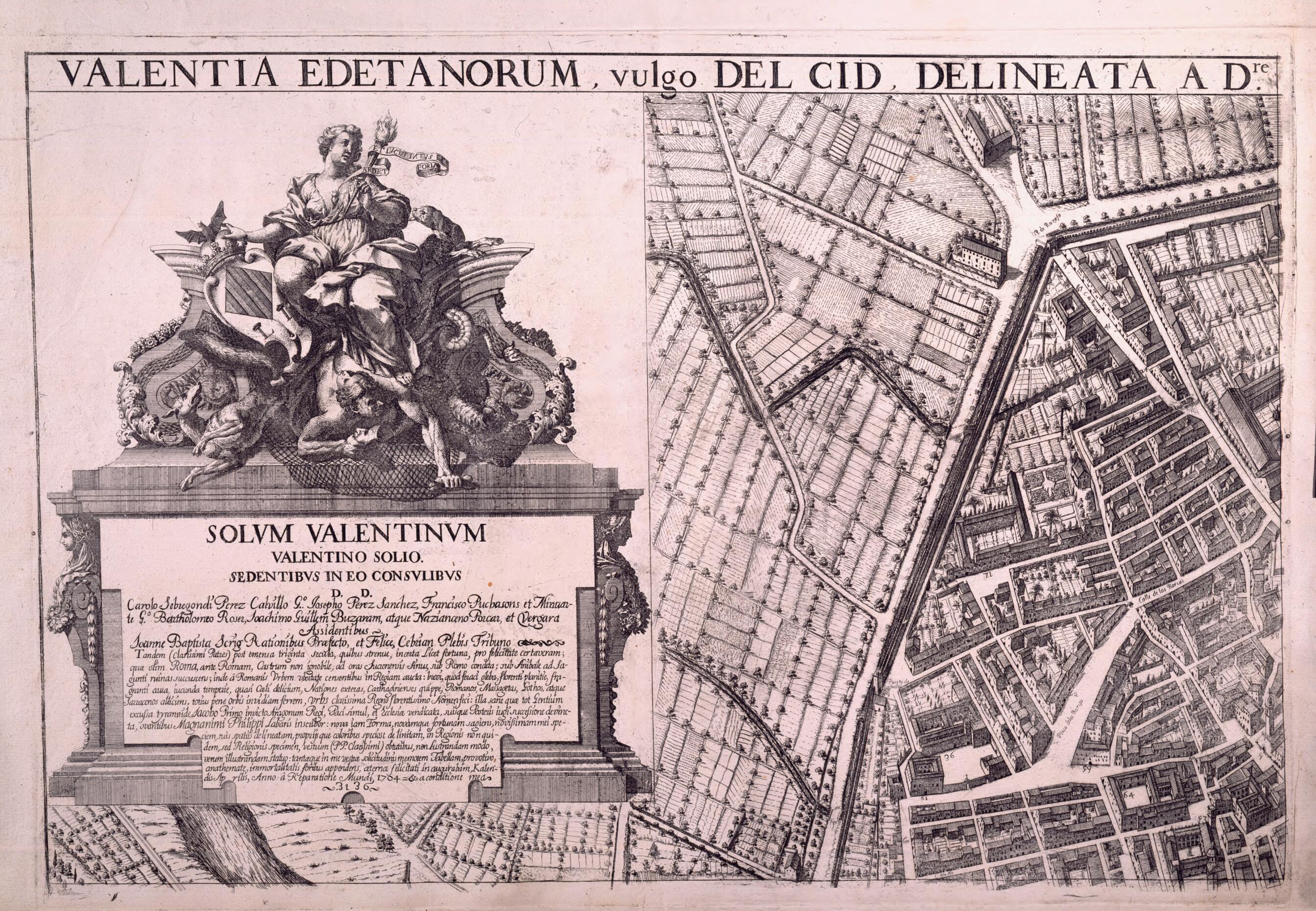
Old map of Spain, Valencia.-1723), a local priest, scholar, mathematician, cartographer, and theologian, who was a founder of the Novatores group, a scientific society established with the aim of challenging and renewing prevailing ideas and practices. Father Tosca's most important book was Compendio Matemático (Mathematical compendium), a nine-volume work composed in 1707--15 that covered, in addition to mathematics and geometry, such subjects as astronomy, geography, seamanship, military architecture, optics, and perspective. The success of this work was such that several editions were made and it was translated into other languages, including German, French, and Italian. Tosca also designed and built a large geographic globe. Tosca's map of Valencia, produced in 1704, provides detailed views of public and private buildings, streets, squares, and other features of the city. The top left corner of the map shows an allegory of the city, by Joseph Fortea, in which the matron holds the coat of arms of the city and carries a torch in her hand; a ribbon protrudes from her heart with the legend Ardet et lucet intus et foris (Burns and shines within and without). In the bottom corner, in a large baroque cartouche decorated with patterns relating to mathematics and the fine arts, is the key to the map or "Explanation of the notes." It has a long list of parishes, convents, schools, hospitals, palaces, houses, fish markets, and other places in the city. The scale, on the third sheet, is expressed as one to 1,200 Valencian palms (a unit of length equal to 14.7 centimeters).
Created by José Fortea, Tomás Vicente Tosca in 1705.
- Title devised, in English, by Library staff.
- "Scale 1:1,800. Relief shown by hachures."--Note extracted from World Digital Library.
- Original resource extent: 1 plan on 4 sheets: engraving, 102 x 146 centimeters in sheets of 49 x 71 centimeters.
- Original resource at: National Library of Spain.
- Content in Latin.
- Description based on data extracted from World Digital Library, which may be extracted from partner institutions.
- For the best legibility, order your map in the original size or larger. Most maps have intricate detail and small text that is best appreciated when the print size hasn't been reduced.
- Sizes labeled "Fits a Standard Frame" will drop right into any frame that you purchase in that size. The sizes that we offer are commonly available online and at most retail stores.
- Our standard sizes are recommendations based on the aspect ratio of the original map, but still may require some added "white space" in one dimension to fit.
- Non-standard sizes will require custom framing, and we suggest taking your print to the frame shop of your choice after you receive it for the best results.
- Custom sizes are available, simply contact us for a quote.
Below is an approximation of the scale of a few standard sizes, and how they might appear in your space.
