
Variations of the Compass for the Year 1925 1926
- Regular price
-
$164.95 - Regular price
-
$159.95 - Sale price
-
$164.95
Buy one map, get any other map in our collection for 50% OFF! Add to cart to see discount.
Couldn't load pickup availability
About This Map
Discover the timeless beauty of our fine art quality printed reproduction of this antique map. Perfect for history enthusiasts, collectors, and interior decorators.
Restored with meticulous attention to detail by our team with over a decade of experience, this stunning reproduction captures the intricate artistry and historical significance of the original map.
Whether you're a collector or seeking a unique decor piece, this archival-quality map reproduction is a timeless addition to any space. Order now to bring history to life!
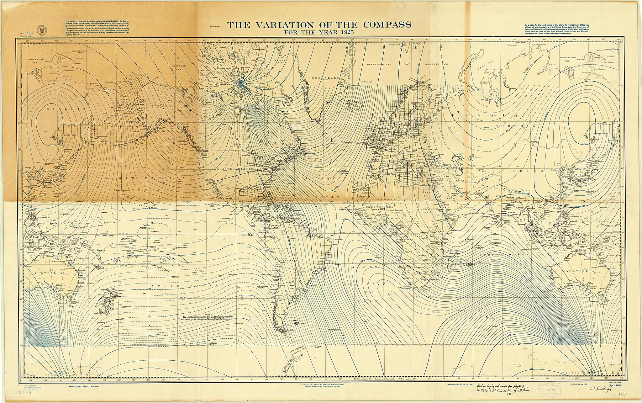
-74) was the American aviator who made the first nonstop solo flight across the Atlantic Ocean on May 21--22, 1927. Because Lindbergh relied on the dead-reckoning method of navigation, this map would have been useful in determining the magnetic declination (the angular difference between magnetic north and true north).Created by Charles A. (Charles Augustus) Lindbergh, United States. Hydrographic Office in 1926.
- Title devised, in English, by Library staff.
- "Scale 1:29,000,000. 2nd edition. H.O. chart no. 2406."--Note extracted from World Digital Library.
- Original resource extent: 1 map : color, annotated ; 80 x 128 centimeters.
- Original resource at: University of Wisconsin-Milwaukee Libraries.
- Content in English.
- Description based on data extracted from World Digital Library, which may be extracted from partner institutions.
Map Subjects
Flight
Magnetic Declination
Nautical Charts
Transatlantic Flights
World Maps
Charles A. (Charles Augustus) Lindbergh
United States. Hydrographic Office
1926
- For the best legibility, order your map in the original size or larger. Most maps have intricate detail and small text that is best appreciated when the print size hasn't been reduced.
- Sizes labeled "Fits a Standard Frame" will drop right into any frame that you purchase in that size. The sizes that we offer are commonly available online and at most retail stores.
- Our standard sizes are recommendations based on the aspect ratio of the original map, but still may require some added "white space" in one dimension to fit.
- Non-standard sizes will require custom framing, and we suggest taking your print to the frame shop of your choice after you receive it for the best results.
- Custom sizes are available, simply contact us for a quote.
Below is an approximation of the scale of a few standard sizes, and how they might appear in your space.
