
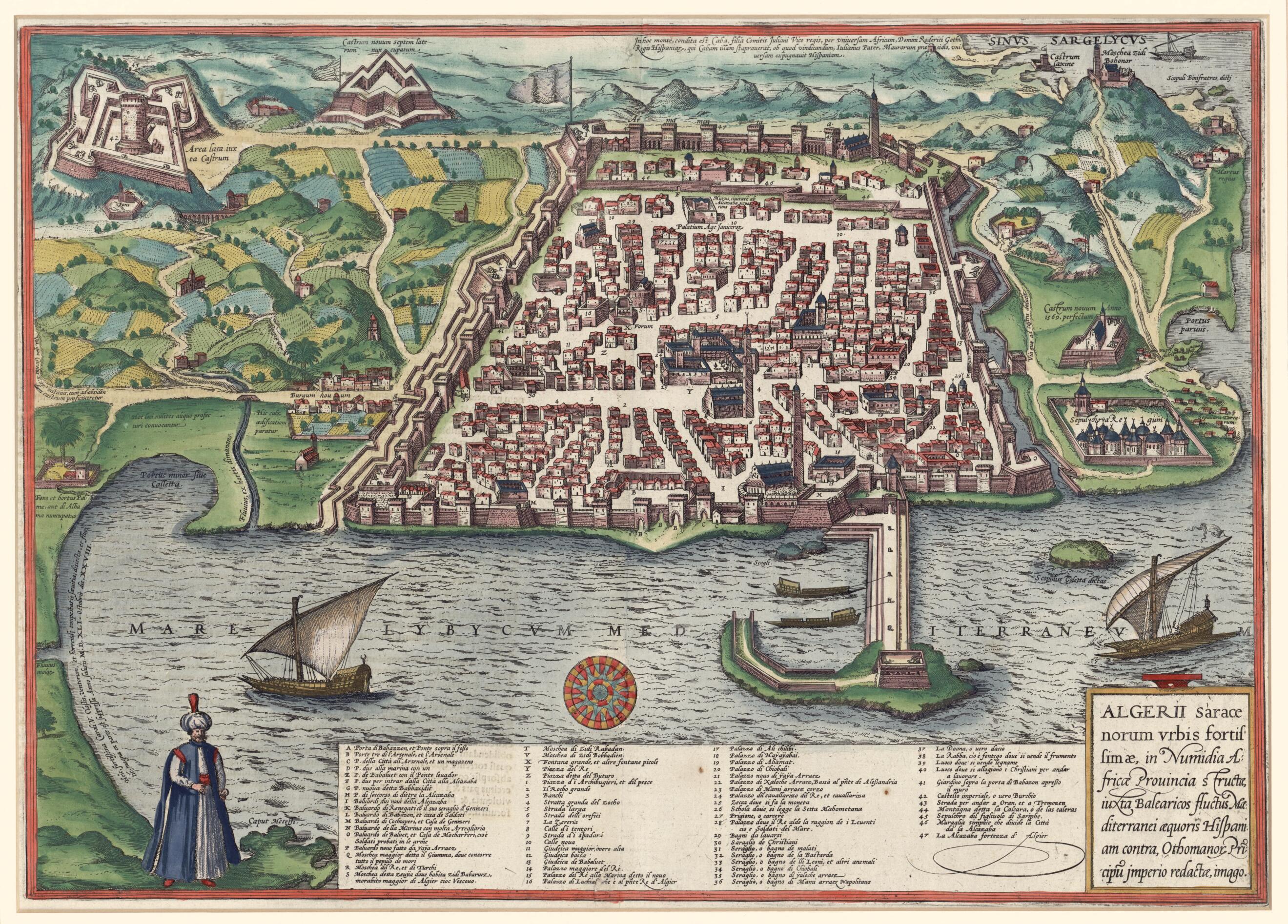
View of Algiers, Seat of Power of the Saracens, In the Numidian Province of Africa and Situated On the Edge of the Balearic Current In the Mediterranean Sea, Across from Spain, Under the Princes of the Ottoman Empire. (Algerii Saracenorum Vrbis Fortis...
- Regular price
-
$61.95 - Regular price
-
$56.95 - Sale price
-
$61.95
Buy one map, get any other map in our collection for 50% OFF! Add to cart to see discount.
Couldn't load pickup availability
About This Map
Discover the timeless beauty of our fine art quality printed reproduction of this antique map. Perfect for history enthusiasts, collectors, and interior decorators.
Restored with meticulous attention to detail by our team with over a decade of experience, this stunning reproduction captures the intricate artistry and historical significance of the original map.
Whether you're a collector or seeking a unique decor piece, this archival-quality map reproduction is a timeless addition to any space. Order now to bring history to life!
Old map of Algeria, Algiers.1622) and Franz Hogenberg (circa 1535-90) and appeared in their Civitates orbis terrarum (The cities of the world), which was published in Cologne, Germany in six volumes between 1572 and 1616. The Civitates was an extraordinary cartographic achievement that consisted of more than 550 plans and views of cities from all the world as it was understood by Europeans at the time. Braun conceived the project and compiled the descriptive texts for each plate. The layout and scheme for the enterprise resembles the Theatrum orbis terrarum (Theater of the world) by Ortelius, which was also engraved by Hogenberg. The title cartouche and notations on the map are in Latin, while the extensive legend is in Italian. The plate shows the formidably fortified town in a low bird's-eye view. Five mosques are marked, as are several synagogues, cemeteries, palaces, the prison, public baths, and other sites. A mustachioed figure in headdress and kaftan stands at lower left. Algiers was a thriving city under a series of Berber dynasties from the tenth to the 16th centuries. It came under Spanish influence from the early 1300s onward. In 1516 the Greco-Turkish pirate Kheireddin Barbarossa (1478--1546) established himself at Algiers, put an end to Spanish influence, and in 1529 accepted Ottoman sovereignty.
Created by Georg Braun, Franz Hogenberg in 1575.
- Title devised, in English, by Library staff.
- Original resource extent: 1 map : color ; 35 x 49 centimeters.
- Original resource at: Qatar National Library.
- Content in Italian and Latin.
- Description based on data extracted from World Digital Library, which may be extracted from partner institutions.
- For the best legibility, order your map in the original size or larger. Most maps have intricate detail and small text that is best appreciated when the print size hasn't been reduced.
- Sizes labeled "Fits a Standard Frame" will drop right into any frame that you purchase in that size. The sizes that we offer are commonly available online and at most retail stores.
- Our standard sizes are recommendations based on the aspect ratio of the original map, but still may require some added "white space" in one dimension to fit.
- Non-standard sizes will require custom framing, and we suggest taking your print to the frame shop of your choice after you receive it for the best results.
- Custom sizes are available, simply contact us for a quote.
Below is an approximation of the scale of a few standard sizes, and how they might appear in your space.

