
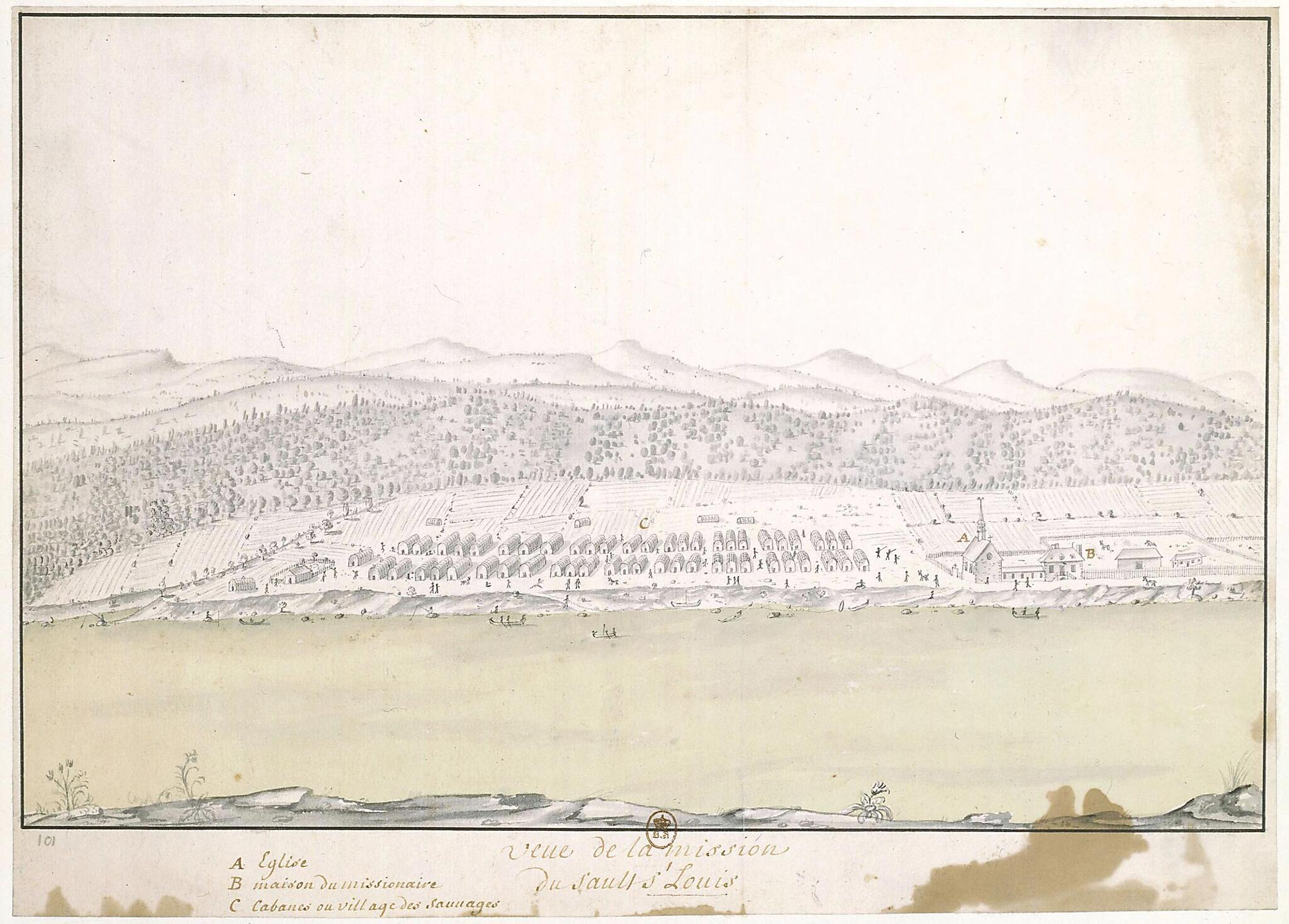
Saint-Louis. (Vue De La Mission Du Sault St Louis) 1730
- Regular price
-
$49.95 - Regular price
-
$34.95 - Sale price
-
$49.95
Buy one map, get any other map in our collection for 50% OFF! Add to cart to see discount.
Couldn't load pickup availability
About This Map
Discover the timeless beauty of our fine art quality printed reproduction of this antique map. Perfect for history enthusiasts, collectors, and interior decorators.
Restored with meticulous attention to detail by our team with over a decade of experience, this stunning reproduction captures the intricate artistry and historical significance of the original map.
Whether you're a collector or seeking a unique decor piece, this archival-quality map reproduction is a timeless addition to any space. Order now to bring history to life!
Old map of Canada, Kahnawake, Quebec.Saint-Louis (present-day Caughnawaga or Kahnawake, near Montreal, Canada). Founded on the banks of the Saint Lawrence River in 1680, the mission was where the Jesuit Joseph-François Lafitau lived among the Iroquois for five years, from 1712 to 1717. Lafitau was educated in rhetoric and philosophy and steeped in theology and the classics. At age 31, he went to Canada as a missionary, where, with the help of Father Julien Garnier, he studied the language and culture of the Iroquois. He was appointed the head of the missions to New France in 1722, and in 1724 completed his major work Mœurs des sauvages américains (Customs of the American Indians). Lafitau's approach was to try to use what was known about ancient peoples, such as the Hebrews and the Greeks, to better understand the culture of the Native Americans. His goal was to prove the common origins of Indians and Europeans, and thereby to corroborate the Christian belief in the unity of creation. Lafitau systematically employed a method of comparative scientific anthropology, which also had been used by André Thevet and Marc Lescarbot. He was extremely precise in his descriptions, which was rare at the time. He came to understand the system of classifying relationships used by the Iroquois, as well as the importance of women in Iroquois society, which he called a "gynecocracy." He also discovered that ginseng was native to North America and was used as a remedy for fever by the Iroquois. Lafitau became head of Sault-Saint-Louis mission in 1727, before permanently returning to France in 1729. He held the office of procurator of the Jesuit missions in New France from 1723 to 1741. The drawing shows the mission church, the compound where the missionaries lived, and the Iroquois village. In the foreground is the Saint Lawrence River. It is not known who made the drawing.
- Title devised, in English, by Library staff.
- Original resource extent: 1 drawing : pen, ink wash and watercolor ; 27 x 37.6 centimeters.
- Original resource at: National Library of France.
- Content in French.
- Description based on data extracted from World Digital Library, which may be extracted from partner institutions.
Map Subjects
Canada
Catholic Church
France In America
Indians Of North America
Indigenous Peoples
Iroquois Indians
Jesuits
Kahnawake
Manuscript Maps
Missionaries
Missions
New France
Quebec
Villages
1730
- For the best legibility, order your map in the original size or larger. Most maps have intricate detail and small text that is best appreciated when the print size hasn't been reduced.
- Sizes labeled "Fits a Standard Frame" will drop right into any frame that you purchase in that size. The sizes that we offer are commonly available online and at most retail stores.
- Our standard sizes are recommendations based on the aspect ratio of the original map, but still may require some added "white space" in one dimension to fit.
- Non-standard sizes will require custom framing, and we suggest taking your print to the frame shop of your choice after you receive it for the best results.
- Custom sizes are available, simply contact us for a quote.
Below is an approximation of the scale of a few standard sizes, and how they might appear in your space.

