
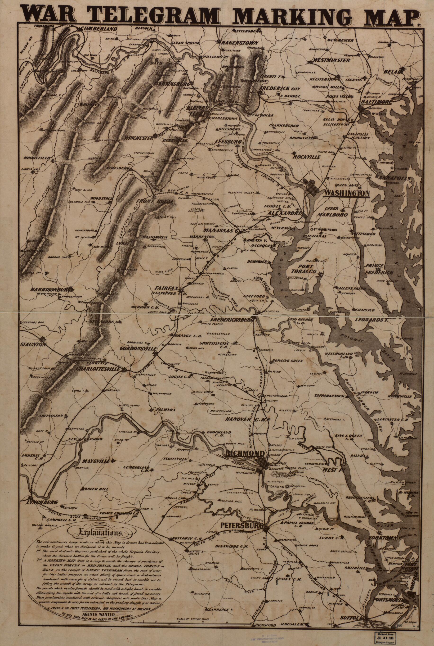
War Telegram Marking Map 1862
- Regular price
-
$91.95 - Regular price
-
$86.95 - Sale price
-
$91.95
Buy one map, get any other map in our collection for 50% OFF! Add to cart to see discount.
Couldn't load pickup availability
About This Map
Discover the timeless beauty of our fine art quality printed reproduction of this antique map. Perfect for history enthusiasts, collectors, and interior decorators.
Restored with meticulous attention to detail by our team with over a decade of experience, this stunning reproduction captures the intricate artistry and historical significance of the original map.
Whether you're a collector or seeking a unique decor piece, this archival-quality map reproduction is a timeless addition to any space. Order now to bring history to life!
Old map of Middle Atlantic States, United States.Created by Louis Prang and Company in 1862.
- Scale ca. 1:490,000.
- Civil War Map
- Base map depicting eastern Virignia printed in brown ink.
- "Entered according to Act of Congress in the year 1862 by L. Prang & Co."
- "Explanations. The extraordinary large scale on which this map is drawn has been adopted to make it just what we designed it to be, namely 1st. The most distinct map ever published of the whole Virginia territory, where the decisive battles for the Union will be fought. 2nd. A marking map, that is a map to mark the change of positions of the Union forces in red pencil and the rebel forces in blue, on the receipt of every telegram from the seat of war . . ."
- In this issue, Hixford, Virginia, south of Petersburg, has been changed to Hicksford.
- Description derived from published bibliography.
- For the best legibility, order your map in the original size or larger. Most maps have intricate detail and small text that is best appreciated when the print size hasn't been reduced.
- Sizes labeled "Fits a Standard Frame" will drop right into any frame that you purchase in that size. The sizes that we offer are commonly available online and at most retail stores.
- Our standard sizes are recommendations based on the aspect ratio of the original map, but still may require some added "white space" in one dimension to fit.
- Non-standard sizes will require custom framing, and we suggest taking your print to the frame shop of your choice after you receive it for the best results.
- Custom sizes are available, simply contact us for a quote.
Below is an approximation of the scale of a few standard sizes, and how they might appear in your space.

