
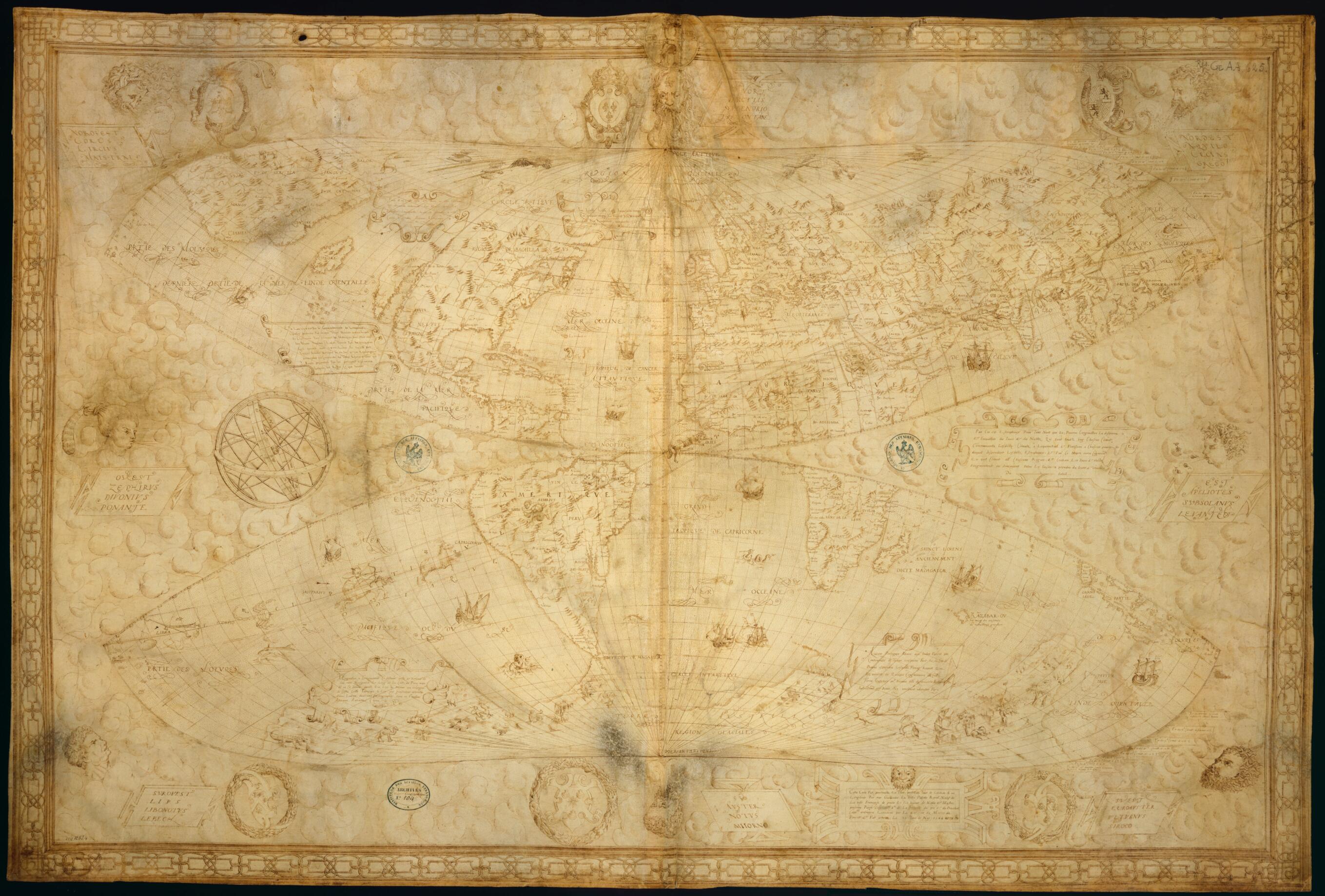
World Map In Two Hemispheres (Bonne Projection), in 1566
- Regular price
-
$151.95 - Regular price
-
$146.95 - Sale price
-
$151.95
Buy one map, get any other map in our collection for 50% OFF! Add to cart to see discount.
Couldn't load pickup availability
About This Map
Discover the timeless beauty of our fine art quality printed reproduction of this antique map. Perfect for history enthusiasts, collectors, and interior decorators.
Restored with meticulous attention to detail by our team with over a decade of experience, this stunning reproduction captures the intricate artistry and historical significance of the original map.
Whether you're a collector or seeking a unique decor piece, this archival-quality map reproduction is a timeless addition to any space. Order now to bring history to life!
72). Bonne maps used a modified conical map projection from circa 1500; the parallels appeared as equally spaced concentric arcs of a circle and the maps had a straight vertical central meridian. The Norman school of hydrographers was active in the French maritime province of Normandy, chiefly in the city of Dieppe, from the early 16th century to the middle of the 17th century. Its cartographers were all skilled in mathematics and exhibited great mastery of the different cartographic projections in use at that time. They were for the most part also pilots and sailors with extensive experience at sea. Le Testu is reported to have made many voyages to the Americas and Africa. His familiarity with the Grand Banks off the coast of Newfoundland is indicated by the phrase Banc ou ce fait la pesche des morues (Bank where cod fishing is done). Certain regions on the map are still undetermined, for example northern Europe, Labrador, California, and the region of Siberia, Alaska, and the North Pacific. The inscription states: "This map was drawn in total perfection, in both latitude and longitude, by myself, Guillaume Le Testu, royal pilot, native of the French city of Grace... and completed on May 23, 1566."Created by Guillaume Le Testu in 1566.
- Title devised, in English, by Library staff.
- Original resource extent: 1 map : manuscript vellum ; 79 x 118 centimeters.
- Original resource at: National Library of France.
- Content in French.
- Description based on data extracted from World Digital Library, which may be extracted from partner institutions.
- For the best legibility, order your map in the original size or larger. Most maps have intricate detail and small text that is best appreciated when the print size hasn't been reduced.
- Sizes labeled "Fits a Standard Frame" will drop right into any frame that you purchase in that size. The sizes that we offer are commonly available online and at most retail stores.
- Our standard sizes are recommendations based on the aspect ratio of the original map, but still may require some added "white space" in one dimension to fit.
- Non-standard sizes will require custom framing, and we suggest taking your print to the frame shop of your choice after you receive it for the best results.
- Custom sizes are available, simply contact us for a quote.
Below is an approximation of the scale of a few standard sizes, and how they might appear in your space.
