
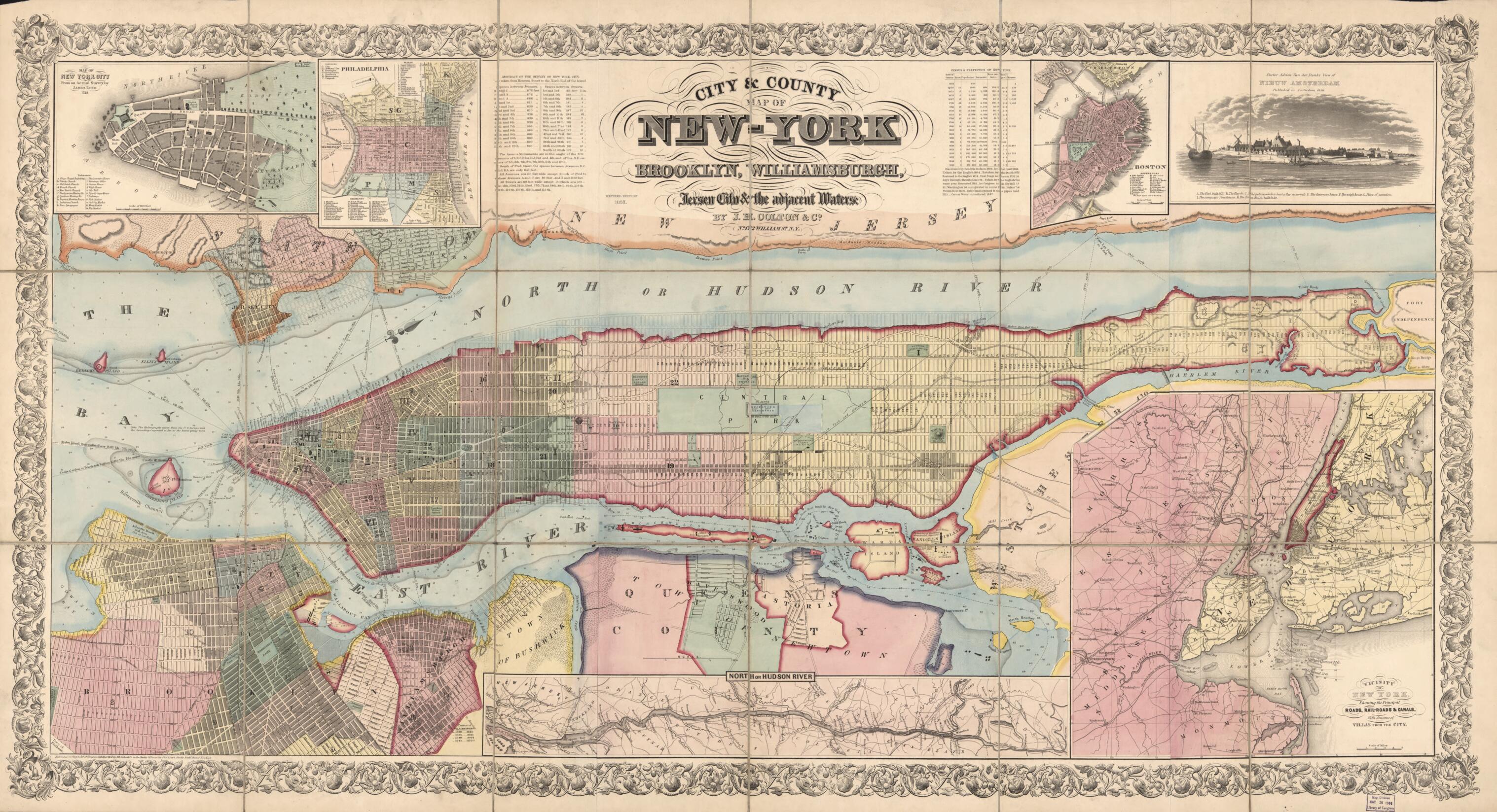
York : Brooklyn, Williamsburgh, Jersey City & the Adjacent Waters (York) 1857
- Regular price
-
$164.95 - Regular price
-
$159.95 - Sale price
-
$164.95
Buy one map, get any other map in our collection for 50% OFF! Add to cart to see discount.
Couldn't load pickup availability
About This Map
Discover the timeless beauty of our fine art quality printed reproduction of this antique map. Perfect for history enthusiasts, collectors, and interior decorators.
Restored with meticulous attention to detail by our team with over a decade of experience, this stunning reproduction captures the intricate artistry and historical significance of the original map.
Whether you're a collector or seeking a unique decor piece, this archival-quality map reproduction is a timeless addition to any space. Order now to bring history to life!
Old facsimile of Boston, Brooklyn, Brookyln (New York), Hudson River Valley, Jersey City, Massachusetts, New Jersey, New York, New York (State), New York City, New York Metropolitan Area, New York Metropolitian Area, New York Region, Pennsylvania, Philadelphia, United States, Williamsburg, Williamsburg (New York).up areas, streetcar/railroad lines, river piers (numbered, proprietors identified), municipal wards (numbered), and projected street-system grid to the northern end of Manhattan Island.
Created by Millard Fillmore, J.H. Colton & Co, James Lyne in 1857.
- Relief shown by hachures; depths shown by soundings.
- Titie from map area (upper center); there in no title on the cover.
- Oriented with north toward the upper right.
- Hand colored to emphasize shorelines, municipal boundaries, and ward extents.
- "Entered according to Act of Congress in the year 1857 by J.H. Colton & Co. in the Clerks Office of the Dist. Court for the South'n Dist. of New York."
- Originally printed on 4 sheets (later conjoined).
- Sectioned to 18 panels to enable folding.
- Ward maps of United States cities, no. 159.
- Includes texts, 2 statistical tables (street dimensions and census data), indexes to points-of-interest for the inset maps, engraved low-angle view of early "Nieuw Amsterdam" (1656), and embellished border.
- Insets: Map of New York City from an actual survey by James Lyne 1728 -- Philadelphia -- Boston -- Vicinity of New York showing the principal roads, rail-roads & canals, with distance of villas from the city -- North or Hudson River [valley from New York to Glens Falls].
- The cover (on verso) is affixed as 2 separate panels.
- For the best legibility, order your map in the original size or larger. Most maps have intricate detail and small text that is best appreciated when the print size hasn't been reduced.
- Sizes labeled "Fits a Standard Frame" will drop right into any frame that you purchase in that size. The sizes that we offer are commonly available online and at most retail stores.
- Our standard sizes are recommendations based on the aspect ratio of the original map, but still may require some added "white space" in one dimension to fit.
- Non-standard sizes will require custom framing, and we suggest taking your print to the frame shop of your choice after you receive it for the best results.
- Custom sizes are available, simply contact us for a quote.
Below is an approximation of the scale of a few standard sizes, and how they might appear in your space.
