725 products
-
 Image 69 of Sketch Book of Jed. Hotchkiss, Capt. & Top. Eng., Hd. Qrs., 2nd Corps, Army of N. Virginia : Virginia from Sketch Book of Jed. Hotchkiss, Capt. & Top. Eng., Hd. Qrs., 2nd Corps, Army of N. Virginia : Virginia 1862Image 69 of Sketch Book of Jed. Hotchkiss, Capt. & Top. Eng., Hd. Qrs., 2nd Corps, Army of N. Virginia : Virginia from Sketch Book of Jed. Hotchkiss, Capt. & Top. Eng., Hd. Qrs., 2nd Corps, Army of N. Virginia : Virginia 1862
- Regular price
-
$39.95 $83.95 - Regular price
-
$19.95 - Sale price
-
$39.95 $83.95
-
 Image 62 of Sketch Book of Jed. Hotchkiss, Capt. & Top. Eng., Hd. Qrs., 2nd Corps, Army of N. Virginia : Virginia from Sketch Book of Jed. Hotchkiss, Capt. & Top. Eng., Hd. Qrs., 2nd Corps, Army of N. Virginia : Virginia 1862Image 62 of Sketch Book of Jed. Hotchkiss, Capt. & Top. Eng., Hd. Qrs., 2nd Corps, Army of N. Virginia : Virginia from Sketch Book of Jed. Hotchkiss, Capt. & Top. Eng., Hd. Qrs., 2nd Corps, Army of N. Virginia : Virginia 1862
- Regular price
-
$39.95 $83.95 - Regular price
-
$19.95 - Sale price
-
$39.95 $83.95
-
 Image 115 of Sketch Book of Jed. Hotchkiss, Capt. & Top. Eng., Hd. Qrs., 2nd Corps, Army of N. Virginia : Virginia from Sketch Book of Jed. Hotchkiss, Capt. & Top. Eng., Hd. Qrs., 2nd Corps, Army of N. Virginia : Virginia 1862Image 115 of Sketch Book of Jed. Hotchkiss, Capt. & Top. Eng., Hd. Qrs., 2nd Corps, Army of N. Virginia : Virginia from Sketch Book of Jed. Hotchkiss, Capt. & Top. Eng., Hd. Qrs., 2nd Corps, Army of N. Virginia : Virginia 1862
- Regular price
-
$39.95 $83.95 - Regular price
-
$19.95 - Sale price
-
$39.95 $83.95
-
 Image 8 of Sketch Book of Jed. Hotchkiss, Capt. & Top. Eng., Hd. Qrs., 2nd Corps, Army of N. Virginia : Virginia from Sketch Book of Jed. Hotchkiss, Capt. & Top. Eng., Hd. Qrs., 2nd Corps, Army of N. Virginia : Virginia 1862Image 8 of Sketch Book of Jed. Hotchkiss, Capt. & Top. Eng., Hd. Qrs., 2nd Corps, Army of N. Virginia : Virginia from Sketch Book of Jed. Hotchkiss, Capt. & Top. Eng., Hd. Qrs., 2nd Corps, Army of N. Virginia : Virginia 1862
- Regular price
-
$39.95 $83.95 - Regular price
-
$18.95 - Sale price
-
$39.95 $83.95
-
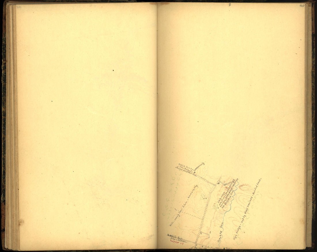 Image 53 of Sketch Book of Jed. Hotchkiss, Capt. & Top. Eng., Hd. Qrs., 2nd Corps, Army of N. Virginia : Virginia from Sketch Book of Jed. Hotchkiss, Capt. & Top. Eng., Hd. Qrs., 2nd Corps, Army of N. Virginia : Virginia 1862Image 53 of Sketch Book of Jed. Hotchkiss, Capt. & Top. Eng., Hd. Qrs., 2nd Corps, Army of N. Virginia : Virginia from Sketch Book of Jed. Hotchkiss, Capt. & Top. Eng., Hd. Qrs., 2nd Corps, Army of N. Virginia : Virginia 1862
- Regular price
-
$39.95 $83.95 - Regular price
-
$19.95 - Sale price
-
$39.95 $83.95
-
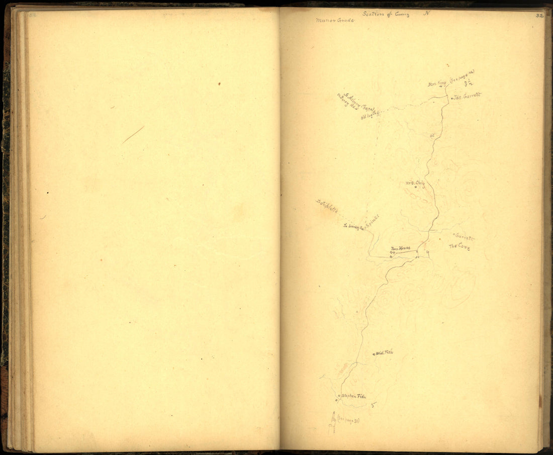 Image 41 of Sketch Book of Jed. Hotchkiss, Capt. & Top. Eng., Hd. Qrs., 2nd Corps, Army of N. Virginia : Virginia from Sketch Book of Jed. Hotchkiss, Capt. & Top. Eng., Hd. Qrs., 2nd Corps, Army of N. Virginia : Virginia 1862Image 41 of Sketch Book of Jed. Hotchkiss, Capt. & Top. Eng., Hd. Qrs., 2nd Corps, Army of N. Virginia : Virginia from Sketch Book of Jed. Hotchkiss, Capt. & Top. Eng., Hd. Qrs., 2nd Corps, Army of N. Virginia : Virginia 1862
- Regular price
-
$39.95 $83.95 - Regular price
-
$19.95 - Sale price
-
$39.95 $83.95
-
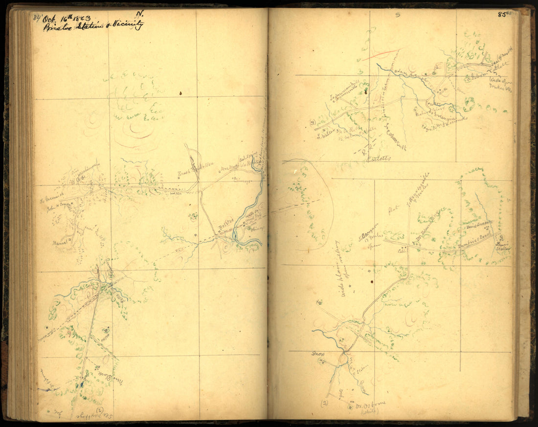 Image 93 of Sketch Book of Jed. Hotchkiss, Capt. & Top. Eng., Hd. Qrs., 2nd Corps, Army of N. Virginia : Virginia from Sketch Book of Jed. Hotchkiss, Capt. & Top. Eng., Hd. Qrs., 2nd Corps, Army of N. Virginia : Virginia 1862Image 93 of Sketch Book of Jed. Hotchkiss, Capt. & Top. Eng., Hd. Qrs., 2nd Corps, Army of N. Virginia : Virginia from Sketch Book of Jed. Hotchkiss, Capt. & Top. Eng., Hd. Qrs., 2nd Corps, Army of N. Virginia : Virginia 1862
- Regular price
-
$39.95 $83.95 - Regular price
-
$20.95 - Sale price
-
$39.95 $83.95
-
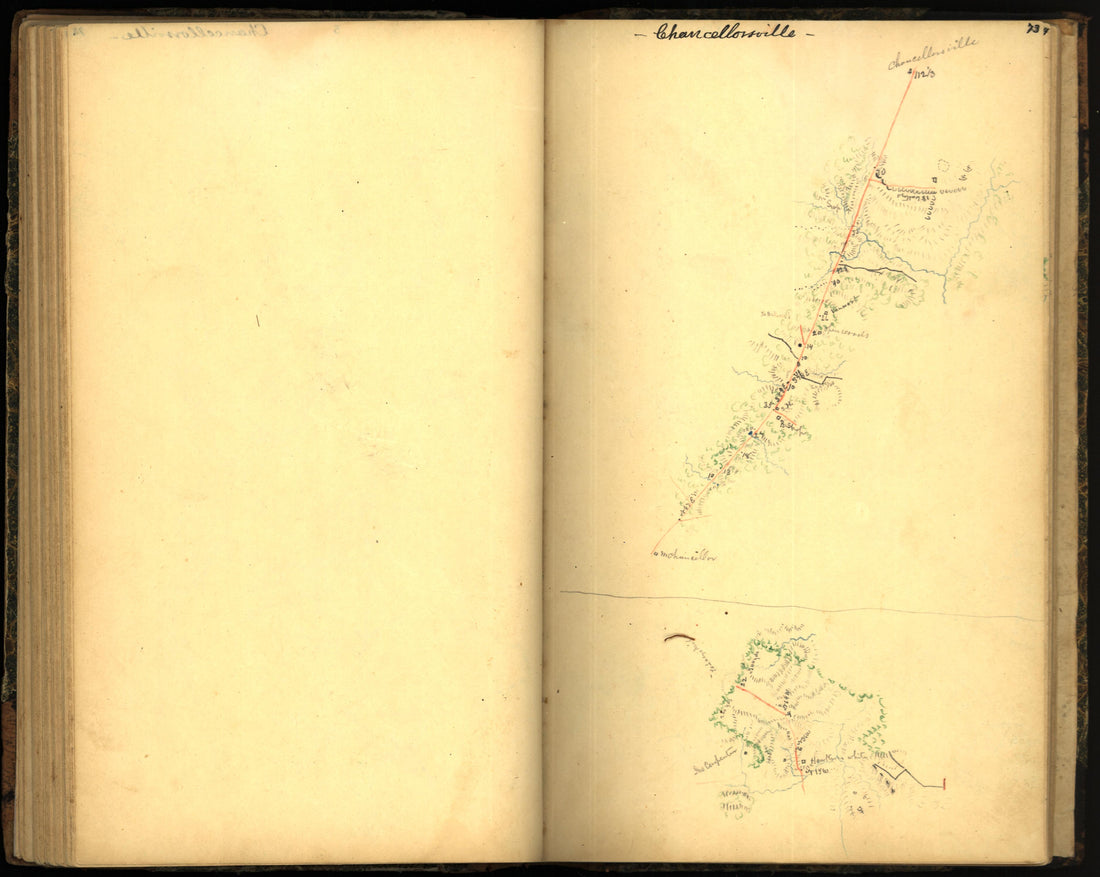 Image 81 of Sketch Book of Jed. Hotchkiss, Capt. & Top. Eng., Hd. Qrs., 2nd Corps, Army of N. Virginia : Virginia from Sketch Book of Jed. Hotchkiss, Capt. & Top. Eng., Hd. Qrs., 2nd Corps, Army of N. Virginia : Virginia 1862Image 81 of Sketch Book of Jed. Hotchkiss, Capt. & Top. Eng., Hd. Qrs., 2nd Corps, Army of N. Virginia : Virginia from Sketch Book of Jed. Hotchkiss, Capt. & Top. Eng., Hd. Qrs., 2nd Corps, Army of N. Virginia : Virginia 1862
- Regular price
-
$39.95 $83.95 - Regular price
-
$20.95 - Sale price
-
$39.95 $83.95
-
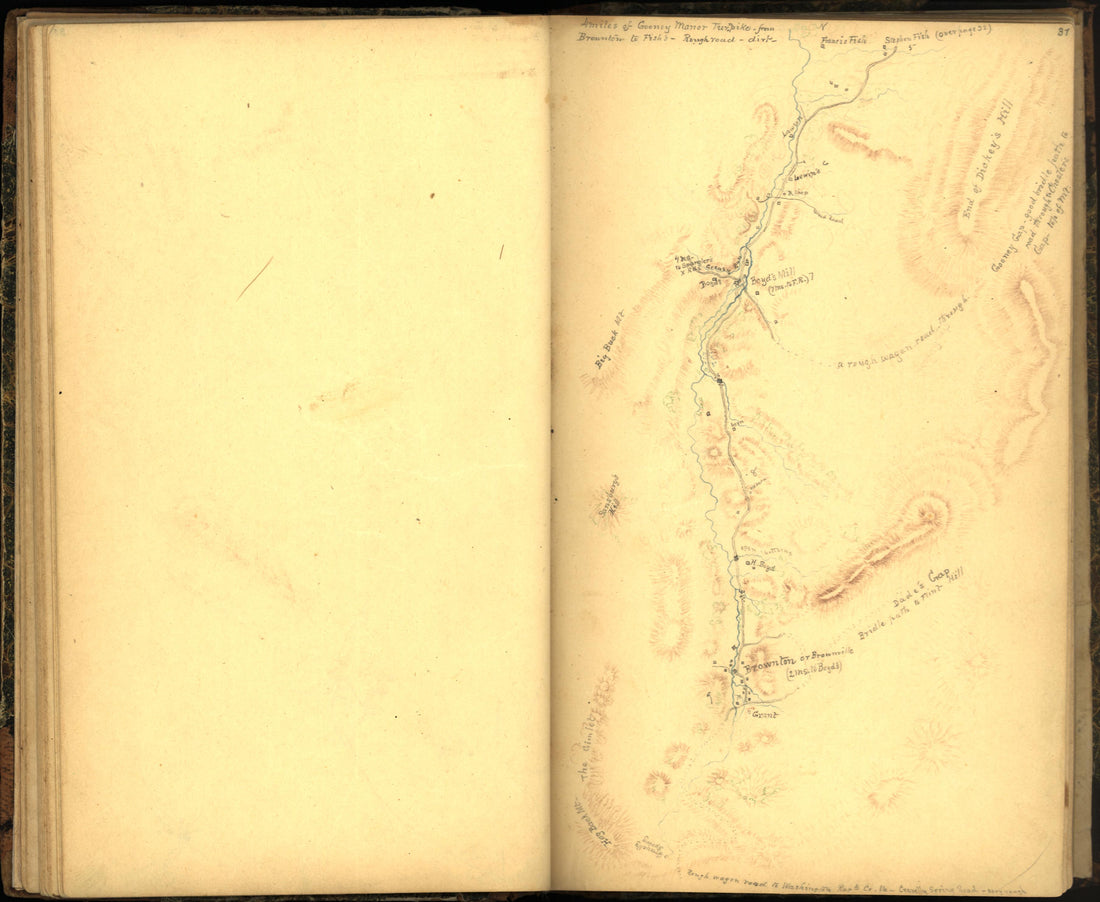 Image 40 of Sketch Book of Jed. Hotchkiss, Capt. & Top. Eng., Hd. Qrs., 2nd Corps, Army of N. Virginia : Virginia from Sketch Book of Jed. Hotchkiss, Capt. & Top. Eng., Hd. Qrs., 2nd Corps, Army of N. Virginia : Virginia 1862Image 40 of Sketch Book of Jed. Hotchkiss, Capt. & Top. Eng., Hd. Qrs., 2nd Corps, Army of N. Virginia : Virginia from Sketch Book of Jed. Hotchkiss, Capt. & Top. Eng., Hd. Qrs., 2nd Corps, Army of N. Virginia : Virginia 1862
- Regular price
-
$39.95 $83.95 - Regular price
-
$19.95 - Sale price
-
$39.95 $83.95
-
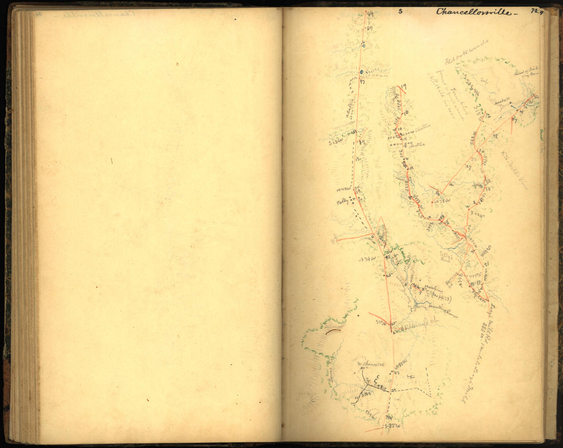 Image 80 of Sketch Book of Jed. Hotchkiss, Capt. & Top. Eng., Hd. Qrs., 2nd Corps, Army of N. Virginia : Virginia from Sketch Book of Jed. Hotchkiss, Capt. & Top. Eng., Hd. Qrs., 2nd Corps, Army of N. Virginia : Virginia 1862Image 80 of Sketch Book of Jed. Hotchkiss, Capt. & Top. Eng., Hd. Qrs., 2nd Corps, Army of N. Virginia : Virginia from Sketch Book of Jed. Hotchkiss, Capt. & Top. Eng., Hd. Qrs., 2nd Corps, Army of N. Virginia : Virginia 1862
- Regular price
-
$39.95 $83.95 - Regular price
-
$19.95 - Sale price
-
$39.95 $83.95
-
 Image 58 of Sketch Book of Jed. Hotchkiss, Capt. & Top. Eng., Hd. Qrs., 2nd Corps, Army of N. Virginia : Virginia from Sketch Book of Jed. Hotchkiss, Capt. & Top. Eng., Hd. Qrs., 2nd Corps, Army of N. Virginia : Virginia 1862Image 58 of Sketch Book of Jed. Hotchkiss, Capt. & Top. Eng., Hd. Qrs., 2nd Corps, Army of N. Virginia : Virginia from Sketch Book of Jed. Hotchkiss, Capt. & Top. Eng., Hd. Qrs., 2nd Corps, Army of N. Virginia : Virginia 1862
- Regular price
-
$39.95 $83.95 - Regular price
-
$19.95 - Sale price
-
$39.95 $83.95
-
 Image 30 of Sketch Book of Jed. Hotchkiss, Capt. & Top. Eng., Hd. Qrs., 2nd Corps, Army of N. Virginia : Virginia from Sketch Book of Jed. Hotchkiss, Capt. & Top. Eng., Hd. Qrs., 2nd Corps, Army of N. Virginia : Virginia 1862Image 30 of Sketch Book of Jed. Hotchkiss, Capt. & Top. Eng., Hd. Qrs., 2nd Corps, Army of N. Virginia : Virginia from Sketch Book of Jed. Hotchkiss, Capt. & Top. Eng., Hd. Qrs., 2nd Corps, Army of N. Virginia : Virginia 1862
- Regular price
-
$39.95 $83.95 - Regular price
-
$19.95 - Sale price
-
$39.95 $83.95


