66 products
-
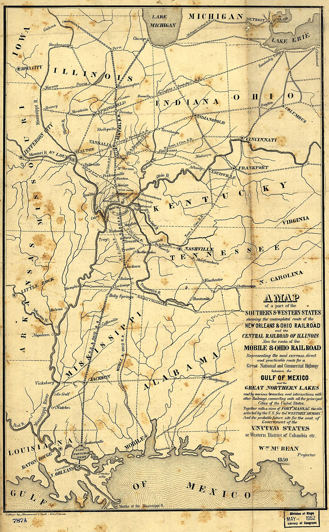 A Map of a Part of the Southern & Western States Showing the Contemplated Route of the New Orleans & Ohio Railroad and the Central Railroad of Illinois, Also the Route of the Mobile & Ohio Railroad Representing the Most Central, Direct and Practicable...A Map of a Part of the Southern & Western States Showing the Contemplated Route of the New Orleans & Ohio Railroad and the Central Railroad of Illinois, Also the Route of the Mobile & Ohio Railroad Representing the Most Central, Direct and Practicable...
- Regular price
-
$39.95 $99.95 - Regular price
-
$34.95 - Sale price
-
$39.95 $99.95
-
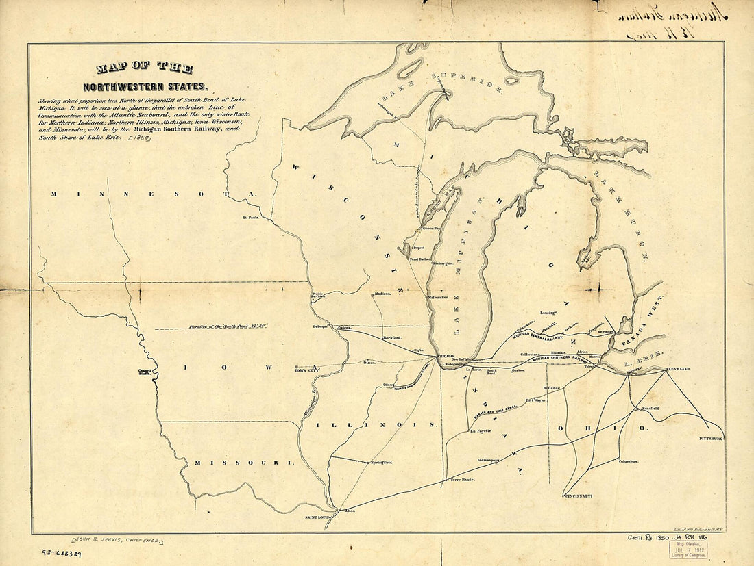 Map of the Northwestern States. Shewing sic What Proportion Lies North of the Parallel of South Bend of Lake Michigan. It Will Be Seen at a Glance, That the Unbroken Line of Communication With the Atlantic Seaboard, and the Only Winter Route for North...Map of the Northwestern States. Shewing sic What Proportion Lies North of the Parallel of South Bend of Lake Michigan. It Will Be Seen at a Glance, That the Unbroken Line of Communication With the Atlantic Seaboard, and the Only Winter Route for North...
- Regular price
-
$43.95 $88.95 - Regular price
-
$38.95 - Sale price
-
$43.95 $88.95
-
 A Chart of the Internal Part of Louisiana : Including All the Hitherto Unexplored Countries, Lying Between the River La Platte of the Missouri On the N., and the Red River On the S., the Mississippi East, and the Mountains of Mexico West, With a Part ...A Chart of the Internal Part of Louisiana : Including All the Hitherto Unexplored Countries, Lying Between the River La Platte of the Missouri On the N., and the Red River On the S., the Mississippi East, and the Mountains of Mexico West, With a Part ...
- Regular price
-
$43.95 $111.95 - Regular price
-
$38.95 - Sale price
-
$43.95 $111.95
-
 Railroad and Commercial Map of the Northwest in 1884Railroad and Commercial Map of the Northwest in 1884
- Regular price
-
$43.95 $211.95 - Regular price
-
$38.95 - Sale price
-
$43.95 $211.95
-
 Map Showing the Completed Lines of the Milwaukee and Saint Paul Railway Company in 1872Map Showing the Completed Lines of the Milwaukee and Saint Paul Railway Company in 1872
- Regular price
-
$42.95 $99.95 - Regular price
-
$37.95 - Sale price
-
$42.95 $99.95
-
 Map Showing the Railroad and Highway Bridge Over the Missouri River at St. Joseph, Mo. and the Railroads Connecting Therewith in 1872Map Showing the Railroad and Highway Bridge Over the Missouri River at St. Joseph, Mo. and the Railroads Connecting Therewith in 1872
- Regular price
-
$46.95 $99.95 - Regular price
-
$41.95 - Sale price
-
$46.95 $99.95
-
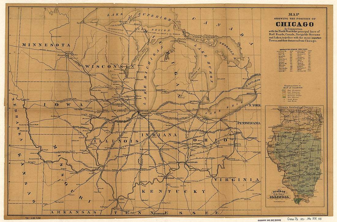 Map Showing the Position of Chicago In Connection With the North West & the Principal Lines of Rail Roads, Canals, Navigable Streams and Lakes, Together With the Most Important Towns, and Their Distances from Chicago 1850Map Showing the Position of Chicago In Connection With the North West & the Principal Lines of Rail Roads, Canals, Navigable Streams and Lakes, Together With the Most Important Towns, and Their Distances from Chicago 1850
- Regular price
-
$46.95 $111.95 - Regular price
-
$41.95 - Sale price
-
$46.95 $111.95
-
 Map Showing the Jacksonville North Western and South Eastern Railway and Its Connections in 1850Map Showing the Jacksonville North Western and South Eastern Railway and Its Connections in 1850
- Regular price
-
$43.95 $83.95 - Regular price
-
$38.95 - Sale price
-
$43.95 $83.95
-
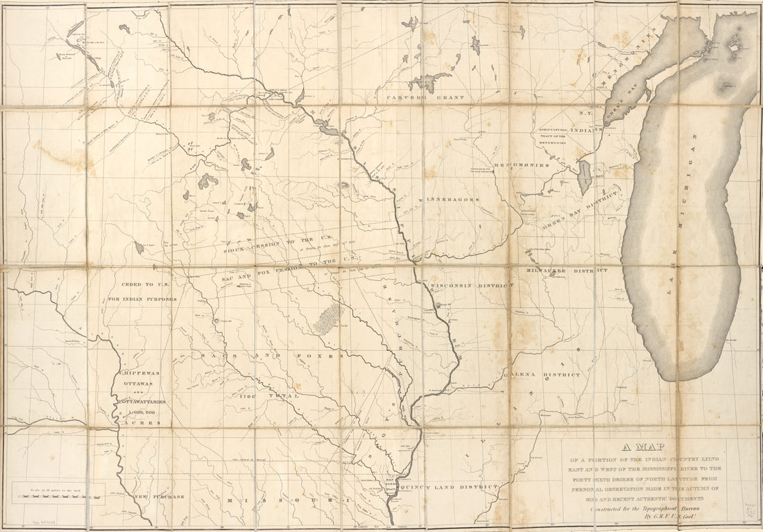 A Map of a Portion of the Indian Country Lying East and West of the Mississippi River to the Forty Sixth Degree of North Latitude From Personal Observation Made In the Autumn of 1835 and Recent Authentic Documents in 1836A Map of a Portion of the Indian Country Lying East and West of the Mississippi River to the Forty Sixth Degree of North Latitude From Personal Observation Made In the Autumn of 1835 and Recent Authentic Documents in 1836
- Regular price
-
$46.95 $187.95 - Regular price
-
$41.95 - Sale price
-
$46.95 $187.95
-
 Bird's Eye View of Junction of the Ohio & Mississippi Rivers, Showing Cairo and Part of the Southern States in 1861Bird's Eye View of Junction of the Ohio & Mississippi Rivers, Showing Cairo and Part of the Southern States in 1861
- Regular price
-
$43.95 $83.95 - Regular price
-
$38.95 - Sale price
-
$43.95 $83.95
-
 Map Showing the Line of the Milwaukee & St. Paul Railroad and Its Western and North Western Connections 1865Map Showing the Line of the Milwaukee & St. Paul Railroad and Its Western and North Western Connections 1865
- Regular price
-
$43.95 $103.95 - Regular price
-
$38.95 - Sale price
-
$43.95 $103.95
-
 Map Showing the Burlington Cedar Rapids and Minnesota Railway and Its Connections 1868Map Showing the Burlington Cedar Rapids and Minnesota Railway and Its Connections 1868
- Regular price
-
$43.95 $91.95 - Regular price
-
$38.95 - Sale price
-
$43.95 $91.95


