428 products
-
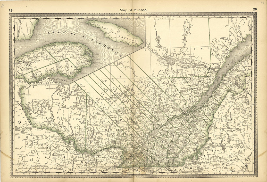 Map of Quebec from Historical Hand-atlas, Illustrated, Containing Large Scale Copper Plate Maps of Each State and Territory of the United States, and the Provinces of Canada, Together With a Complete Reference Map of the World, … 1882Map of Quebec from Historical Hand-atlas, Illustrated, Containing Large Scale Copper Plate Maps of Each State and Territory of the United States, and the Provinces of Canada, Together With a Complete Reference Map of the World, … 1882
- Regular price
-
$49.95 $99.95 - Regular price
-
$36.95 - Sale price
-
$49.95 $99.95
-
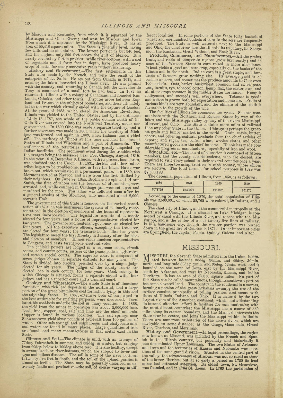 Illinois - Continued, Missouri from Historical Hand-atlas, Illustrated, Containing Large Scale Copper Plate Maps of Each State and Territory of the United States, and the Provinces of Canada, Together With a Complete Reference Map of the World, … 1882Illinois - Continued, Missouri from Historical Hand-atlas, Illustrated, Containing Large Scale Copper Plate Maps of Each State and Territory of the United States, and the Provinces of Canada, Together With a Complete Reference Map of the World, … 1882
- Regular price
-
$49.95 $88.95 - Regular price
-
$23.95 - Sale price
-
$49.95 $88.95
-
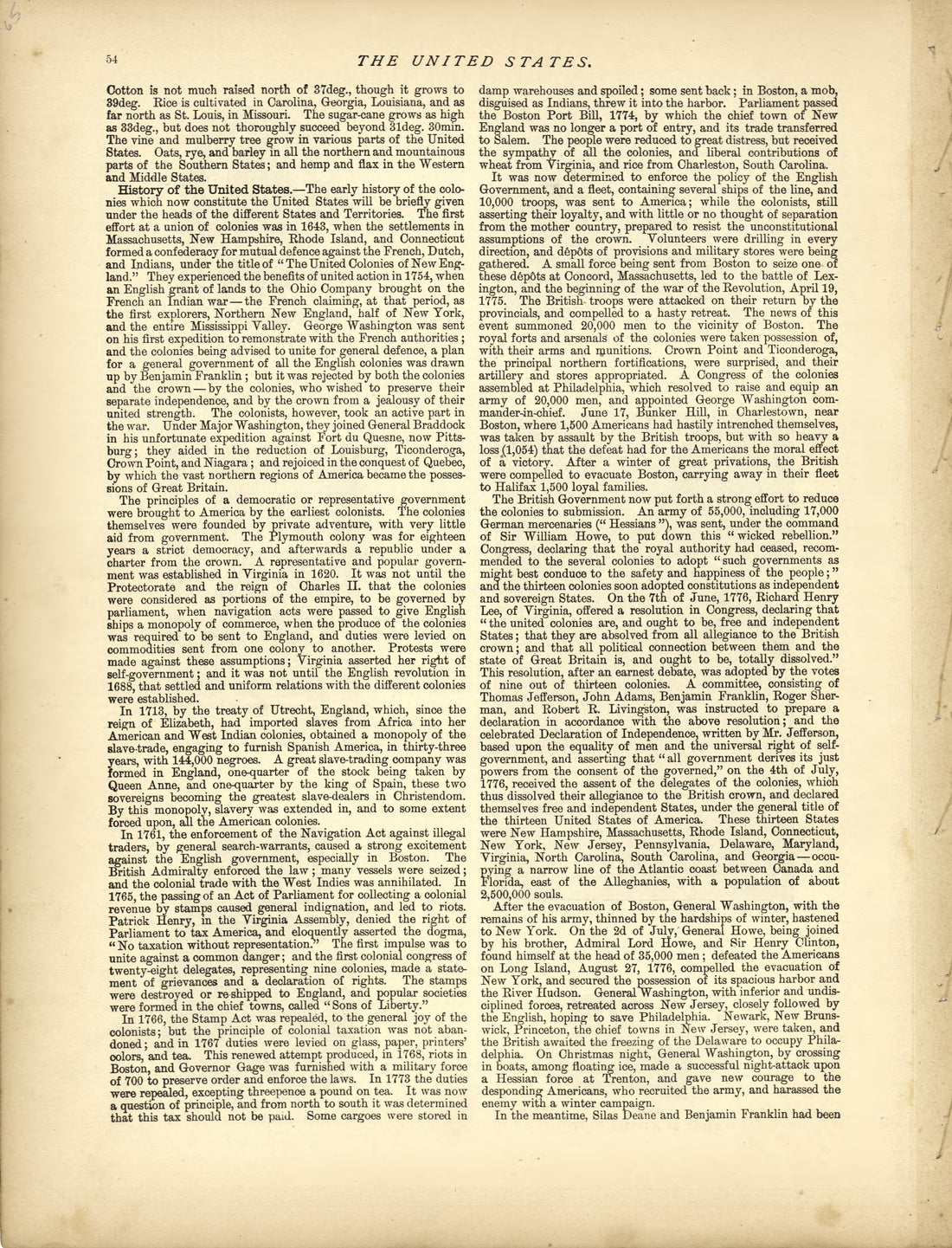 The United States - Continued from Historical Hand-atlas, Illustrated, Containing Large Scale Copper Plate Maps of Each State and Territory of the United States, and the Provinces of Canada, Together With a Complete Reference Map of the World, … 1882The United States - Continued from Historical Hand-atlas, Illustrated, Containing Large Scale Copper Plate Maps of Each State and Territory of the United States, and the Provinces of Canada, Together With a Complete Reference Map of the World, … 1882
- Regular price
-
$49.95 $88.95 - Regular price
-
$25.95 - Sale price
-
$49.95 $88.95
-
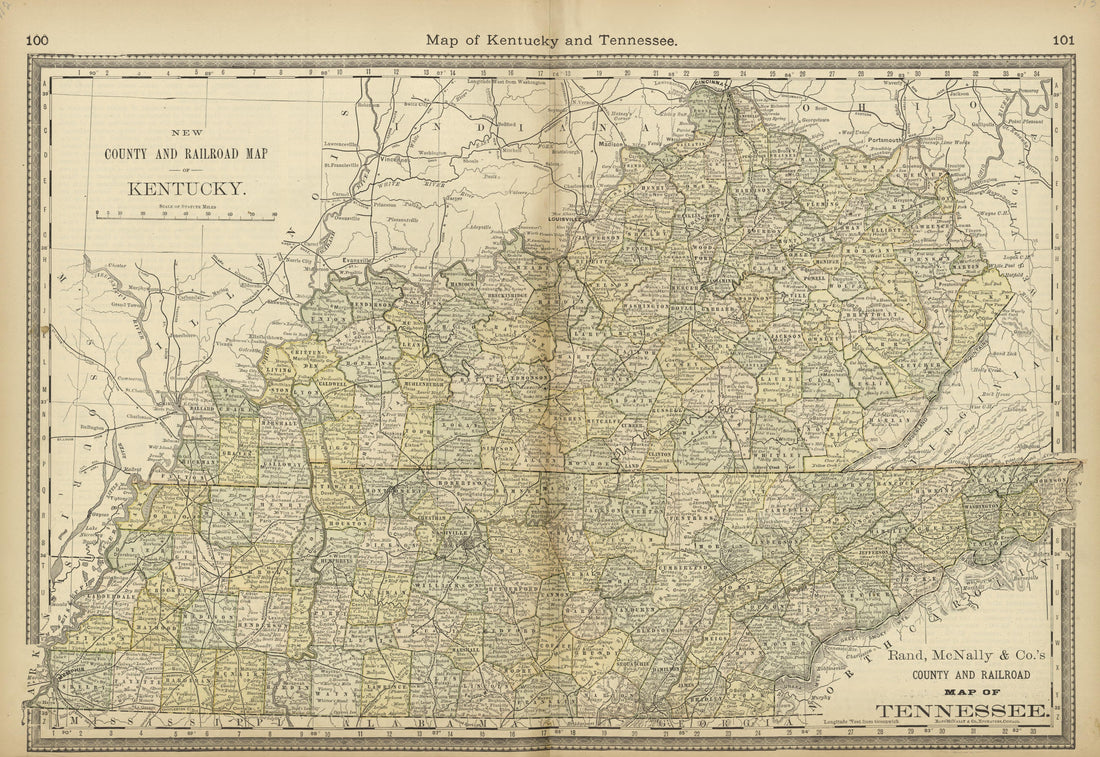 Map of Kentucky and Tennessee from Historical Hand-atlas, Illustrated, Containing Large Scale Copper Plate Maps of Each State and Territory of the United States, and the Provinces of Canada, Together With a Complete Reference Map of the World, … 1882Map of Kentucky and Tennessee from Historical Hand-atlas, Illustrated, Containing Large Scale Copper Plate Maps of Each State and Territory of the United States, and the Provinces of Canada, Together With a Complete Reference Map of the World, … 1882
- Regular price
-
$49.95 $99.95 - Regular price
-
$36.95 - Sale price
-
$49.95 $99.95
-
 Jackson Square and the Cathedral, a Birdseye View of New Orleans, Louisiana from Historical Hand-atlas, Illustrated, Containing Large Scale Copper Plate Maps of Each State and Territory of the United States, and the Provinces of Canada, Together With ...Jackson Square and the Cathedral, a Birdseye View of New Orleans, Louisiana from Historical Hand-atlas, Illustrated, Containing Large Scale Copper Plate Maps of Each State and Territory of the United States, and the Provinces of Canada, Together With ...
- Regular price
-
$49.95 $88.95 - Regular price
-
$24.95 - Sale price
-
$49.95 $88.95
-
 History of the Virginias - Continued from Historical Hand-atlas, Illustrated, Containing Large Scale Copper Plate Maps of Each State and Territory of the United States, and the Provinces of Canada, Together With a Complete Reference Map of the World, ...History of the Virginias - Continued from Historical Hand-atlas, Illustrated, Containing Large Scale Copper Plate Maps of Each State and Territory of the United States, and the Provinces of Canada, Together With a Complete Reference Map of the World, ...
- Regular price
-
$49.95 $88.95 - Regular price
-
$24.95 - Sale price
-
$49.95 $88.95
-
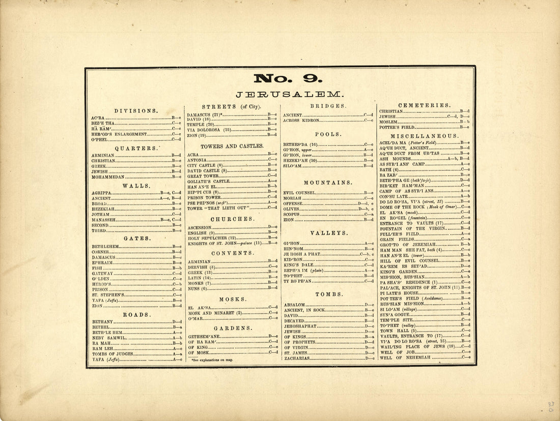 No. 9 Jerusalem from Historical Hand-atlas, Illustrated, Containing Large Scale Copper Plate Maps of Each State and Territory of the United States, and the Provinces of Canada, Together With a Complete Reference Map of the World, … 1882No. 9 Jerusalem from Historical Hand-atlas, Illustrated, Containing Large Scale Copper Plate Maps of Each State and Territory of the United States, and the Provinces of Canada, Together With a Complete Reference Map of the World, … 1882
- Regular price
-
$49.95 $88.95 - Regular price
-
$25.95 - Sale price
-
$49.95 $88.95
-
 History of Wood County - Continued from Historical Hand-atlas, Illustrated, Containing Large Scale Copper Plate Maps of Each State and Territory of the United States, and the Provinces of Canada, Together With a Complete Reference Map of the World, �...History of Wood County - Continued from Historical Hand-atlas, Illustrated, Containing Large Scale Copper Plate Maps of Each State and Territory of the United States, and the Provinces of Canada, Together With a Complete Reference Map of the World, �...
- Regular price
-
$49.95 $88.95 - Regular price
-
$24.95 - Sale price
-
$49.95 $88.95
-
 Texas - Continued, Nebraska and Dakota from Historical Hand-atlas, Illustrated, Containing Large Scale Copper Plate Maps of Each State and Territory of the United States, and the Provinces of Canada, Together With a Complete Reference Map of the World...Texas - Continued, Nebraska and Dakota from Historical Hand-atlas, Illustrated, Containing Large Scale Copper Plate Maps of Each State and Territory of the United States, and the Provinces of Canada, Together With a Complete Reference Map of the World...
- Regular price
-
$49.95 $88.95 - Regular price
-
$23.95 - Sale price
-
$49.95 $88.95
-
 Colonial Architecture, Divinity Hall-Oxford, Landing of the Pilgrims, Others from Historical Hand-atlas, Illustrated, Containing Large Scale Copper Plate Maps of Each State and Territory of the United States, and the Provinces of Canada, Together With...Colonial Architecture, Divinity Hall-Oxford, Landing of the Pilgrims, Others from Historical Hand-atlas, Illustrated, Containing Large Scale Copper Plate Maps of Each State and Territory of the United States, and the Provinces of Canada, Together With...
- Regular price
-
$49.95 $83.95 - Regular price
-
$25.95 - Sale price
-
$49.95 $83.95
-
 History of Wood County - Continued from Historical Hand-atlas, Illustrated, Containing Large Scale Copper Plate Maps of Each State and Territory of the United States, and the Provinces of Canada, Together With a Complete Reference Map of the World, �...History of Wood County - Continued from Historical Hand-atlas, Illustrated, Containing Large Scale Copper Plate Maps of Each State and Territory of the United States, and the Provinces of Canada, Together With a Complete Reference Map of the World, �...
- Regular price
-
$49.95 $88.95 - Regular price
-
$24.95 - Sale price
-
$49.95 $88.95
-
 No. 1 Scripture World On Mercator Projection from Historical Hand-atlas, Illustrated, Containing Large Scale Copper Plate Maps of Each State and Territory of the United States, and the Provinces of Canada, Together With a Complete Reference Map of the...No. 1 Scripture World On Mercator Projection from Historical Hand-atlas, Illustrated, Containing Large Scale Copper Plate Maps of Each State and Territory of the United States, and the Provinces of Canada, Together With a Complete Reference Map of the...
- Regular price
-
$49.95 $88.95 - Regular price
-
$25.95 - Sale price
-
$49.95 $88.95


