Quick links
13434 products
-
Map of the Lower Geyser Basin of the Upper Madison River 1872
 Map of the Lower Geyser Basin of the Upper Madison River 1872
- Regular price
-
From
$41.95 - Regular price
-
$66.99 - Sale price
-
From
$41.95
-
Alexandria City Showing Connections With Washington 1911
 Alexandria City Showing Connections With Washington 1911
- Regular price
-
From
$41.95 - Regular price
-
$66.99 - Sale price
-
From
$41.95
-
Bay of Pensacola, Fortification 1781
 Bay of Pensacola, Fortification 1781
- Regular price
-
From
$19.95 - Regular price
-
$29.95 - Sale price
-
From
$19.95
-
Map of the Territory of the United States From the Mississippi River to the Pacific Ocean; Ordered by Jeff'n Davis, Secretary of War to Accompany the Reports of the Explorations for a Railroad Route in 1858
 Map of the Territory of the United States From the Mississippi River to the Pacific Ocean; Ordered by Jeff'n Davis, Secretary of War to Accompany the Reports of the Explorations for a Railroad Route in 1858
- Regular price
-
From
$34.95 - Regular price
-
$49.99 - Sale price
-
From
$34.95
-
Carte De La Louisiane, Et De La Floride 1780
 Carte De La Louisiane, Et De La Floride 1780
- Regular price
-
From
$31.95 - Regular price
-
$48.95 - Sale price
-
From
$31.95
-
Plan of the Battle of Roanoke Island. North Carolina. Feby 8th 1862 02-08
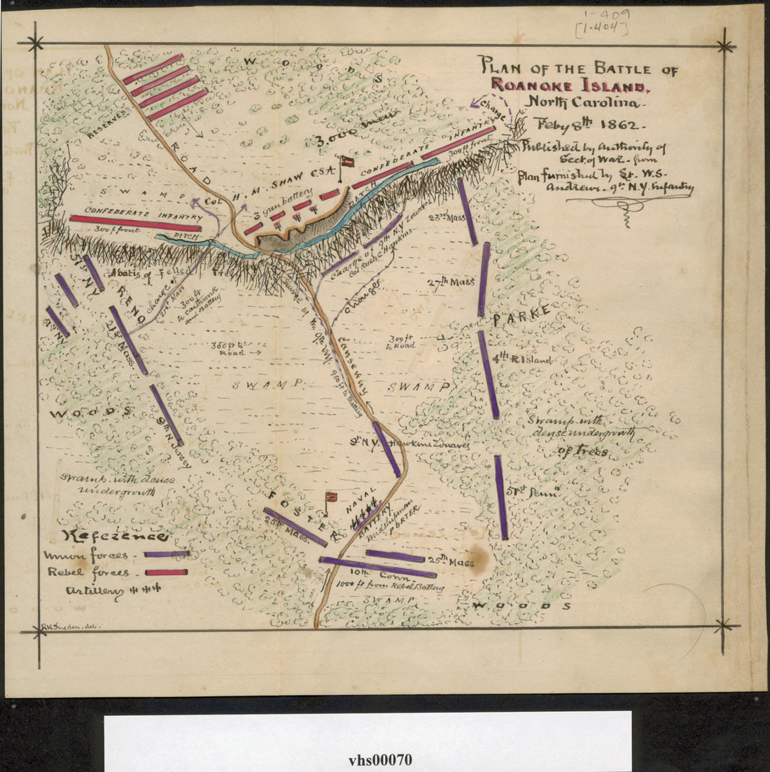 Plan of the Battle of Roanoke Island. North Carolina. Feby 8th 1862 02-08
- Regular price
-
From
$19.95 - Regular price
-
$29.95 - Sale price
-
From
$19.95
-
Plan of the Second Battle of Bull Run, Va. Showing Position of Both Armies at 6 P.m. 29th August 1862 08-29
 Plan of the Second Battle of Bull Run, Va. Showing Position of Both Armies at 6 P.m. 29th August 1862 08-29
- Regular price
-
From
$19.95 - Regular price
-
$29.95 - Sale price
-
From
$19.95
-
Sketch of the Country Illustrating the Late Engagement In Long Island 1776
 Sketch of the Country Illustrating the Late Engagement In Long Island 1776
- Regular price
-
From
$19.95 - Regular price
-
$29.95 - Sale price
-
From
$19.95
-
Roads Between Cape Canso and St. Louis 1851
 Roads Between Cape Canso and St. Louis 1851
- Regular price
-
From
$32.95 - Regular price
-
$51.99 - Sale price
-
From
$32.95
-
Philadelphia Rail-Road 1835
 Philadelphia Rail-Road 1835
- Regular price
-
From
$19.95 - Regular price
-
$29.95 - Sale price
-
From
$19.95
-
Lloyd's Official Map of the State of Tennessee in 1862
 Lloyd's Official Map of the State of Tennessee in 1862
- Regular price
-
From
$41.95 - Regular price
-
$66.99 - Sale price
-
From
$41.95
-
Map of the Great Salt Lake and Adjacent Country In the Territory of Utah : Surveyed In 1849 and 1850 Under the Orders of Col. J.J. Abert in 1852
 Map of the Great Salt Lake and Adjacent Country In the Territory of Utah : Surveyed In 1849 and 1850 Under the Orders of Col. J.J. Abert in 1852
- Regular price
-
From
$41.95 - Regular price
-
$66.99 - Sale price
-
From
$41.95


